


The latest phase of Poompuhar underwater archaeology has recovered West Asian pottery fragments from the seabed, offering new evidence that the ancient Tamil port was part of a wider Indian Ocean trading system. But the larger significance of the discovery lies beyond the objects themselves: archaeologists are trying to reconstruct an urban landscape whose streets, waterfronts and structures may now be submerged beneath the Bay of Bengal.
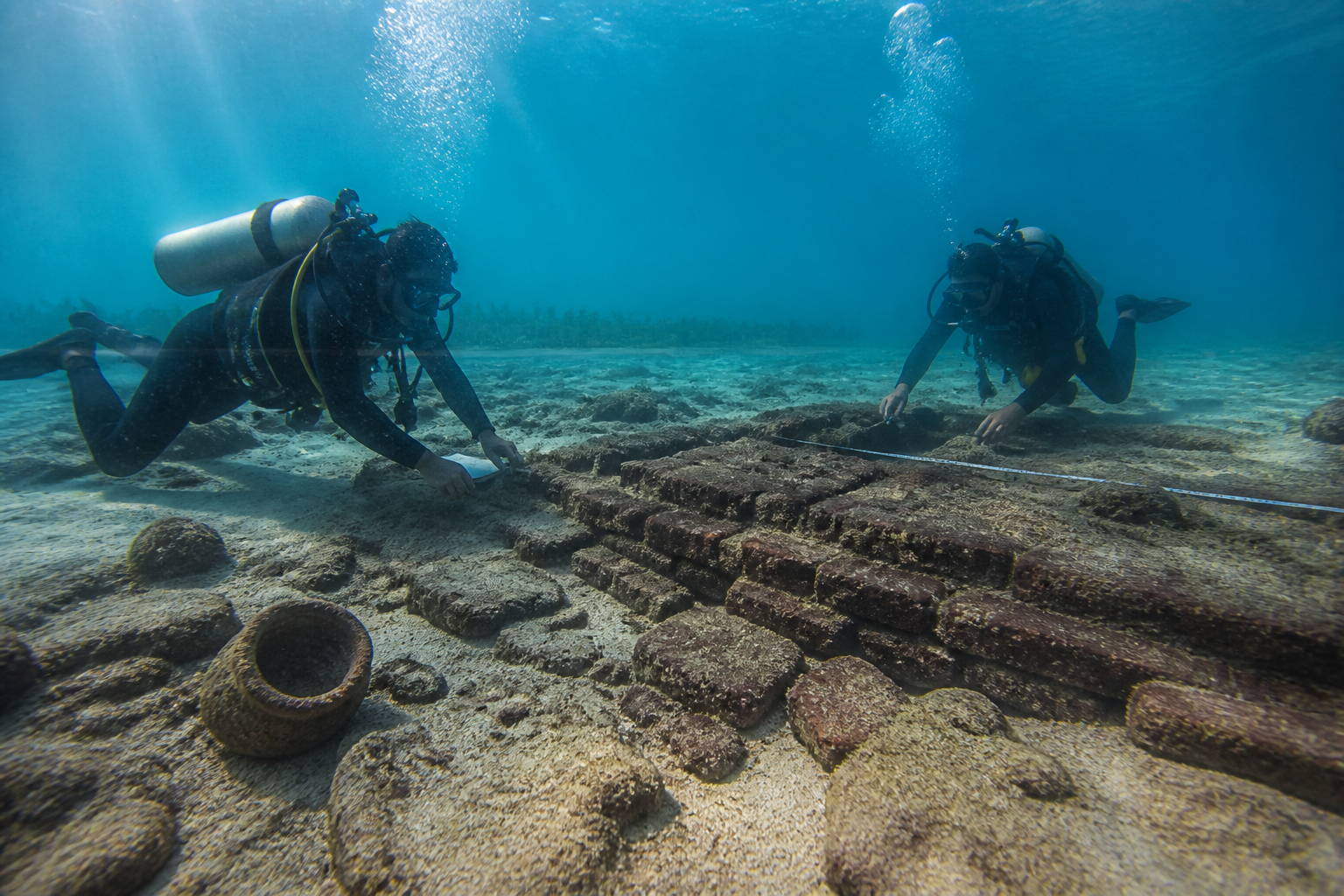
The fragments were found in 10 to 12 metres of water, between 1.8 and 2.2 kilometres from the present shoreline, during the third phase of an underwater exploration project led by the Tamil Nadu State Department of Archaeology in collaboration with the Indian Maritime University. The material includes pieces of a torpedo jar, a transport vessel associated with long-distance trade across the Indian Ocean.
K Rajan, academic advisor to the Tamil Nadu State Department of Archaeology, told The Indian Express that the department was seeking more samples and studying their typology and morphology. He said the discovery showed that the inhabitants of the port city participated in transoceanic trade. The department has sent images of the finds to international specialists, including experts in Italy, for comparison and identification.
The evidence is significant, but it is not yet definitive on every question. Archaeologists have not assigned the torpedo-jar fragments a firm date because such vessels circulated for several centuries. Nor does the presence of a pottery fragment, by itself, establish where the object was manufactured, when it reached Poompuhar or the precise commercial relationship that brought it there. Those conclusions will depend on the archaeological context in which the material is studied.
That distinction is important because Poompuhar has long existed at the intersection of literary memory and physical evidence. Known in ancient accounts as Kaveripoompattinam or Puhar, the port is described in Tamil works including Pattinappalai, Silappathikaram and Manimekalai. The texts refer to a cosmopolitan settlement containing merchants, artisans, warehouses, imported goods and people from different lands and languages.
Archaeology has begun to give physical form to that description. Excavations on land have identified Buddhist structures at Pallavaneswaram, including a Buddhapada, or symbolic representation of the Buddha’s footprints. At Kilaiyur, an Archaeological Survey of India excavation exposed a brick structure interpreted as a wharf, with wooden posts and provision for water movement. Samples from the wooden posts produced a radiocarbon determination of 316 to 103 BCE. A semicircular brick reservoir at Vanagiri, connected to an old course of the Cauvery, has been dated to approximately the first or second century CE.
Together, these remains suggest an urban settlement organised around more than trade alone. The surviving evidence points to religious institutions, water management, landing infrastructure and river-sea connections. Ring wells, Buddhist structures and wharf installations indicate the systems that supported daily life in a port city: access to water, movement of people and goods, storage, worship and contact with visiting merchants.
The offshore discoveries extend that built environment into a space that is now seabed. Archaeologists have reported foreign and local pottery, fragments of ring wells measuring about 60 to 65 centimetres in diameter and structural formations embedded in the seabed. An oval formation has been identified near an earlier recorded U-shaped structure, while another feature is being examined as a possible shipwreck.
This is why the project is not simply an excavation for rare artefacts. It is an attempt to map the extent of an ancient port and its installations, locate possible shipwrecks, and understand changes in sea levels and the course of the Cauvery. The investigation is consequently part archaeology, part coastal reconstruction and part urban history. It asks not only what objects moved through Poompuhar, but also how the landscape that supported the port changed over time.
The question of how Poompuhar was lost remains open. Rajan said researchers were examining several possibilities, including land subsidence, sea-level fluctuations and a tsunami-like phenomenon. The literary tradition adds another layer. Manimekalai describes the city being overwhelmed by the sea after the festival of Indra was neglected, linking the event to a supernatural explanation. Archaeologists do not treat that narrative as geological evidence, but it may preserve a cultural memory of a major coastal transformation.
The difference between memory and evidence is central to the project. Sangam literature describes a living port but does not state that Puhar was swallowed by the sea. Later literary traditions provide a narrative of destruction, while underwater structures, dating evidence and sedimentary or coastal information must establish what physically happened. The work therefore depends on bringing different sources into conversation without treating any one of them as conclusive on its own.
Poompuhar is also part of a larger archaeological geography. Pattanam in Kerala, widely proposed as the ancient port of Muziris although that identification remains debated, has produced Roman amphorae and West Asian ceramics, including torpedo jars and turquoise-glazed pottery. Alagankulam near the Vaigai has yielded Mediterranean-related potsherds, including amphora fragments, alongside red ware bearing Tamil-Brahmi letters assigned to the first century BCE. Arikamedu near Puducherry became a foundational site for understanding India’s early maritime contacts with the Mediterranean world.
The comparison does not prove that all these ports operated as one system or followed identical trajectories. It does show why a fragment recovered from Poompuhar matters. It places the site within a documented pattern of maritime contact in which ports connected river basins, coastlines and overseas trading networks. The latest find adds a material clue to literary references to Yavanas, a term whose meaning broadened in Indian usage over time to include people arriving from the Hellenistic and Roman Mediterranean world and other western regions.
The institutional framework behind the discovery is as important as the artefact. The Tamil Nadu government’s project is being carried out with the Indian Maritime University, while the Centre has granted the state archaeology department a licence for underwater excavation at Poompuhar. The department says only about 10 per cent of the overall underwater exploration has been completed, indicating that the current findings represent an early stage of a much larger mapping exercise.
The state’s 2025-26 Budget earmarked Rs 7 crore for archaeological excavations and scientific research and announced a series of deep-sea archaeological excavations. The first phase was intended to cover the coast from Kaveripoompattinam to Nagapattinam. The stated objective is to investigate the maritime trade of the ancient Tamils with Southeast Asia, the Mediterranean region, the Arabian Peninsula and the Roman Empire.
The project also demonstrates the practical demands of underwater heritage work. The latest phase began on September 6 and concluded on September 22 after an 18-day exploration. Archaeology Minister A Rajmohan underwent scuba-diving training before inspecting the submerged site with Archaeology Director V P Jeyaseelan at a depth of about 10 metres. The department plans to return after the monsoon, with the next phase expected to begin in January.
There is a contemporary coastal question embedded in this ancient one. Rajan said that a sea temple near the coast that he had seen two decades earlier is now underwater. That observation is not, by itself, a complete measurement of shoreline change, but it illustrates the problem the project is trying to document: the coast is not merely a fixed boundary between land and sea. It is a changing environment that can erase, bury or relocate the physical evidence of settlement.
For urban history, Poompuhar offers a particularly valuable case because its disappearance may be studied through the relationship between infrastructure and environmental change. The wharf, reservoir, wells and religious structures show how the city functioned. The offshore formations and submerged artefacts show that the urban footprint may have extended beyond the present shoreline. The archaeological task is to determine the sequence connecting those two conditions.
The evidence currently confirms that Poompuhar was a substantial early port with local and overseas material connections, and that parts of its associated landscape now lie underwater. It does not yet establish a single cause for the city’s submergence, provide a firm date for the torpedo-jar fragments or identify every offshore structure. Those questions will depend on further sampling, specialist comparison, dating and mapping. The next exploration phase after the monsoon will determine how much more of this lost coastal city can be recovered from the seabed.
