


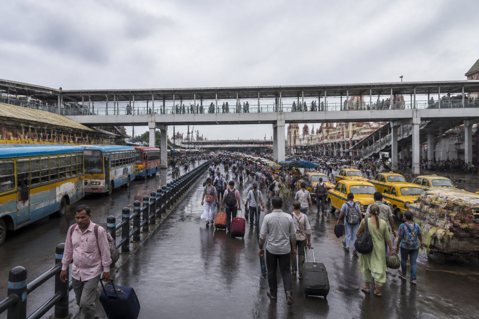
A reported plan to redevelop the Howrah bus-stand area, build a skywalk to Howrah station and improve the underground route to the ferry terminal could reshape how passengers move through one of eastern India’s most important transport gateways. The proposal is significant not only because it promises a new building and commercial facilities, but because it attempts to address the difficult interchange between rail, buses, taxis, cars, ferries and the East-West Metro.
The plan, reported by Anandabazar, envisages a 12- to 13-storey building outside Howrah station. The lower floors would accommodate the bus stand, while upper levels would include parking for two- and four-wheelers, a taxi stand and a parking zone. The building is also expected to include a shopping mall, a food court and a multiplex. A skywalk would connect the bus stand with the railway station, while the underground passage from Howrah station towards the ferry terminal would be renovated.
The reported estimated cost is around Rs 25 crore. The work is expected to involve the railways, the Kolkata Metropolitan Development Authority, the Howrah Municipal Corporation and the administration. The report does not specify a tender date, construction schedule, land-use approval, funding split, design agency or target completion date. Those missing details are important because the proposal covers several public agencies and transport systems, each with separate assets, permissions and operating responsibilities.
Howrah station’s importance makes the access problem larger than the condition of one bus stand. The station handles trains to several parts of the country and attracts large daily passenger flows, according to the report. Bus and taxi traffic around the station is therefore not an incidental local activity. It is part of a continuous movement system in which passengers arriving by train must find buses, taxis, ferries or metro connections, often within a congested and physically fragmented area.
The existing bus-stand environment is described as unhygienic, with water accumulation and scattered waste. These are not only visual or maintenance concerns. Waterlogging can obstruct walking routes, damage surfaces and slow buses and pedestrians. Waste can reduce the usable width of footpaths and create additional pressure on already crowded interchange spaces. A redevelopment that focuses only on a new building, without reliable drainage, waste collection, pedestrian circulation and daily maintenance, would leave the central operational problem unresolved.
The proposed skywalk is therefore the most consequential element for ordinary passengers. A grade-separated pedestrian connection could reduce conflicts between people walking from the bus stand and vehicles entering or leaving the station precinct. It could also provide a more legible route for passengers carrying luggage or transferring between services. But the value of such a structure would depend on where it begins and ends, whether it is accessible to elderly and disabled passengers, how it connects to station entrances, and whether it remains open and safe during the full operating day. The source report does not provide those design details.
The same principle applies to the underground route towards the ferry terminal. Renovating the passage could create a more direct link between the railway station and river transport. The report also says that implementation would make travel from Howrah station to the ferry terminal and the East-West Metro easier. That objective places the project within a wider multimodal network rather than treating the bus stand as an isolated terminal.
Interchange projects often fail when each mode is planned separately. A railway station may have one circulation logic, a bus terminal another, and a ferry or metro access point a third. Passengers experience the gaps between those systems as long walks, unsafe crossings, confusing signage, exposure to rain and congestion. The reported plan appears to recognise the need for physical connections, but it does not yet establish whether the agencies involved have agreed on a common passenger-flow plan.
The proposed building also introduces a second layer of complexity. Combining a bus stand with parking, taxi operations, retail, food services and a multiplex could create a high-intensity transport and commercial complex. Such mixed-use infrastructure can support activity throughout the day, but it can also increase vehicle trips and pedestrian density. The final outcome would depend on how bus bays, taxi queuing, private-car access, deliveries, emergency movement and pedestrian routes are separated within the site.
The reported cost of approximately Rs 25 crore will need to be understood against the scale of the proposal. The article does not clarify whether the estimate covers the entire 12- to 13-storey building, the skywalk, underground passage improvements, parking facilities, utility works, drainage, land acquisition or only an initial phase. It also does not identify whether the commercial components would be funded through public expenditure, a concession, lease revenue or another public-private arrangement. Without that information, the cost cannot be used to assess feasibility or value for money.
The institutional structure is equally important. Railways control key station-related spaces and passenger interfaces. The metropolitan development authority may have planning and infrastructure responsibilities, while the municipal corporation is central to roads, drainage, sanitation and local urban services. The administration would have to coordinate permissions and implementation. The minister cited in the report, Umesh Ray, said that coordinating development work across departments to improve passenger services is a priority. That statement identifies coordination as an objective, but not yet as an operating mechanism.
A clear division of responsibilities would be needed before construction begins. One agency would have to be accountable for project delivery, while others would need defined roles for land, approvals, funding, utilities, security, traffic management and long-term maintenance. The source report does not state whether a single project authority has been appointed. It also does not identify the proposed operator of the redeveloped bus stand, parking areas or commercial facilities.
The choice to include a shopping mall, food court and multiplex raises questions about the balance between transport use and commercial development. Revenue-generating facilities may help support a large interchange, but they should not displace bus circulation, waiting areas, toilets, ticketing, accessibility infrastructure or safe pedestrian movement. The source material confirms the proposed facilities but does not provide a floor-area plan or passenger-capacity assessment. Those documents would be necessary to judge whether the commercial programme supports or competes with the transport function.
The redevelopment also has a ground-level test: whether passengers can move through the area more easily during rain, peak-hour crowding and service disruptions. Howrah’s bus stand is reported to experience water accumulation and waste problems today. Any implementation plan would therefore need to show how drainage, cleaning, toilets, lighting, ventilation, wayfinding and security will be incorporated into the physical design. These are not secondary amenities in a major interchange; they determine whether the infrastructure works on an ordinary day.
The proposal’s relationship with the East-West Metro adds another planning requirement. A connection is useful only when routes are visible, continuous and convenient. If passengers must descend into a poorly maintained passage, cross vehicle lanes or navigate separate entrances without clear signs, the existence of multiple transport modes will not automatically create an integrated interchange. The report establishes the intended connection but does not explain how the metro, rail, bus and ferry paths would be designed as one network.
At this stage, the evidence confirms a broad redevelopment concept, a proposed skywalk, a planned multi-storey transport and commercial building, an upgraded underground passage and an estimated cost. It does not confirm construction commencement, statutory approval, tendering, funding closure or completion timelines. Those milestones will determine whether the announcement becomes a functioning public project or remains a coordination proposal.
The larger urban question is whether Howrah can turn a congested station precinct into a genuinely integrated interchange without allowing commercial development to overwhelm passenger needs. The answer will depend less on the height of the proposed building than on the quality of the connections around it. The next developments to monitor are the formal project plan, agency responsibilities, funding arrangement, design approvals, tender schedule and the measures proposed for drainage, sanitation, accessibility and pedestrian safety.
