


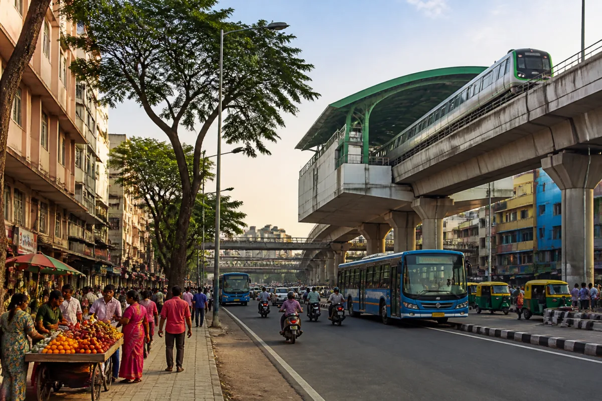
Mahakavi Kuvempu Road is more than a named thoroughfare in west Bengaluru. It is a corridor where older residential neighbourhoods, local commerce, railway infrastructure, bus routes and the modern Namma Metro network meet. Its importance lies less in any single landmark than in the way it connects Rajajinagar, Gayatrinagar, Prakashnagar, Mariyappanapalya and Srirampura with the wider city.
The road’s story also reflects Bengaluru’s layered urban growth. The areas around it belong to an older part of the city, with established housing, markets, schools, hospitals, small businesses and public gardens. At the same time, the corridor now carries a metro station on the Green Line, placing it within a citywide rapid-transit system that links the northern and southern parts of Bengaluru. The result is a transport and neighbourhood corridor shaped by several periods of urban development rather than by one single project.
The road was named in memory of Rashtrakavi Kuvempu, or Kuppali Venkatappa Puttappa, the Jnanpith award-winning Kannada writer whose work holds a prominent place in Karnataka’s cultural history. The naming gives the road a civic and cultural identity, but its everyday significance comes from how it functions. Residents use it to access nearby neighbourhoods, workers and students travel through it, and local traders depend on the movement of people along its commercial stretches.
That combination is important for understanding older Bengaluru. A road in a mature neighbourhood is rarely only a route for vehicles. It is also a boundary, a marketplace, a link between residential areas and public transport, and an address for institutions and services. Mahakavi Kuvempu Road performs all of these roles at once. Its urban character is therefore defined by repeated daily use rather than by a single large development.
### A corridor built through successive layers
The road passes through or near neighbourhoods with decades of history, including Rajajinagar, Gayatrinagar, Prakashnagar, Mariyappanapalya and Srirampura. It is also close to Malleswaram, one of Bengaluru’s older and better-known residential areas. These localities give the corridor a built environment that differs from newly developed peripheral districts. The source describes a mix of established homes, commercial activity, markets, food establishments and institutional uses.
This mix creates a distinctive form of urban accessibility. Everyday needs can be met within the neighbourhood, while larger destinations remain reachable through the road network and public transport. Shops selling groceries, clothing and daily-use goods operate alongside bakeries, restaurants, juice centres and street-food businesses. Such commercial activity is not separate from the road’s transport role; it depends on the steady movement of local residents, commuters and visitors.
The presence of hospitals, educational institutions and major retail destinations nearby adds another layer. Orion Mall and Lulu Mall are identified as important nearby attractions, while Rajajinagar’s hospitals and educational institutions draw users from beyond the immediate residential areas. The road consequently serves both local trips and journeys connected to larger urban destinations.
The railway bridge is one of the clearest reminders that this connectivity developed over time. The bridge linking the Malleswaram side with the area near Navrang cinema was inaugurated in the 1970s, according to the source. It was built at a time when west Bengaluru was expanding and when crossing the railway tracks was an important challenge for movement between Rajajinagar and Malleswaram. The bridge helped establish a more direct connection between neighbourhoods separated by railway infrastructure.
That history matters because it shows how Bengaluru’s transport network has been assembled in stages. The railway bridge addressed one physical barrier. Road links supported the expansion of established neighbourhoods. Bus services connected the corridor to other parts of the city. Decades later, the metro added a higher-capacity public transport layer. Mahakavi Kuvempu Road is therefore a record of changing mobility needs as much as it is a street.
### What the metro added to the corridor
The most significant recent transport addition is Mahakavi Kuvempu Road Metro Station. The elevated station is located on Namma Metro’s north-south Green Line and was opened for public service on March 1, 2024. The line connects Madavara, on the Tumakuru Road side, with Silk Institute, on the Kanakapura Road side.
The station changes the meaning of the road’s connectivity. Before the metro, movement along the corridor depended primarily on road-based transport, including buses and private vehicles. With a metro station, the road becomes an access point to a wider rapid-transit network. People living or working nearby can use the road to reach the station, while the station brings new movement into the surrounding neighbourhoods.
The connection to Nadaprabhu Kempegowda Station, commonly known as Majestic, is particularly important in the source’s account. Majestic is one of Bengaluru’s major transport hubs, and the ability to reach it in a few minutes by metro gives the corridor a direct link to a central interchange. This means that the value of Mahakavi Kuvempu Road is not limited to the destinations immediately alongside it. Its public transport role extends through the metro network.
The road also retains a bus-based mobility function. The source identifies BMTC services including routes 176, 252-FC and 401-B as operating along the corridor. These services provide a different type of access from the metro. Buses can serve intermediate streets and destinations that do not have a station nearby, while the metro provides a faster connection along its fixed corridor. The coexistence of the two systems makes the road a multimodal link rather than a metro-only location.
This distinction is important for neighbourhood-level mobility. A metro station does not replace the need for local connections. Commuters still need to reach the station from their homes, workplaces, schools and markets. Roads and buses perform that first- and last-mile function, even when the longer journey is made by train. In this sense, the station’s effectiveness is connected to the quality and accessibility of the surrounding road and bus network.
### The public life around an infrastructure corridor
Mahakavi Kuvempu Road’s importance cannot be measured only by transport routes. The source describes the road and its surrounding lanes as places associated with old Bengaluru-style hotels, food outlets, juice centres and street food. These uses give the corridor a public life that extends beyond commuting hours.
Local markets also reveal how infrastructure and livelihoods are connected. Grocery stores, clothing shops, bakeries and other daily-use businesses rely on regular footfall. Their presence indicates that the road serves a settled population rather than functioning only as a through-route. The same movement that helps residents reach workplaces and schools also supports small-scale commerce.
The area’s gardens add another dimension. Gayatri Devi Park, also known locally as Elephant Park, near Prakashnagar is described as a favourite place for residents. Green spaces in established neighbourhoods often operate as everyday public infrastructure: they provide places for recreation and informal gathering within walking distance of homes. In the context of Mahakavi Kuvempu Road, the park is part of a broader urban setting that combines transport, commerce, housing and open space.
This combination distinguishes the corridor from a transport project considered in isolation. A metro station can be mapped as a point, a road as a line and a neighbourhood as a boundary. Daily urban life does not follow those separate categories. Residents experience them together, moving from a home to a bus stop, from a market to a metro station, or from a road to a public garden. The corridor’s significance comes from these overlapping uses.
The source describes thousands of employees, students and traders travelling along the road every day. That description points to a broad user base, although it does not provide a passenger count or traffic survey. The available evidence therefore supports the conclusion that the road is heavily used and socially important, but not a precise measurement of its transport performance.
### What the corridor reveals about Bengaluru’s urban structure
Mahakavi Kuvempu Road demonstrates how older urban areas adapt when new infrastructure is inserted into an already established city. The neighbourhoods around it were not created as a single, contemporary transport-oriented development. They evolved through successive phases: residential expansion, road connections, railway crossings, bus operations, commercial intensification and, later, metro access.
This sequence also explains why the corridor contains different kinds of urban value. Its cultural identity comes from the name of Kuvempu. Its historical identity is visible in the older neighbourhoods and the 1970s railway bridge. Its economic identity is expressed through markets, shops, food businesses and nearby institutions. Its mobility identity now includes the Green Line metro station and BMTC routes.
The institutional picture is similarly distributed. Namma Metro provides the rapid-transit connection, BMTC operates the cited bus services, and the road and bridge provide the physical links through which neighbourhoods connect. The source does not provide details of current traffic management, pedestrian infrastructure, station access arrangements or maintenance responsibilities, so those aspects cannot be assessed from the available material. What can be established is that several transport modes and urban functions converge along the same corridor.
That convergence creates both strength and complexity. A connected road can support access to jobs, education, health services and commerce. At the same time, a corridor carrying buses, cars, pedestrians and metro users has to serve very different movement patterns. The source does not provide data on congestion, crashes, footpath conditions or travel times, so it does not establish how efficiently these demands are currently managed. It does, however, show why the road matters beyond its formal name or physical length.
The central urban question is how a mature neighbourhood corridor can retain its local identity while absorbing additional movement generated by modern transit. Mahakavi Kuvempu Road already carries the memory of older Bengaluru and the reach of a newer metropolitan transport system. Its future significance will depend on how these layers continue to work together, although the supplied account does not provide evidence on planned upgrades or upcoming interventions.
For now, the evidence presents Mahakavi Kuvempu Road as a compact illustration of Bengaluru’s broader urban evolution. A road named for a major cultural figure links historic residential areas, a railway bridge built during west Bengaluru’s expansion, local markets and public spaces, BMTC bus routes and a metro station opened in 2024. Its story is not simply about a road. It is about how a city’s old neighbourhoods remain connected as new infrastructure is added around them.

