


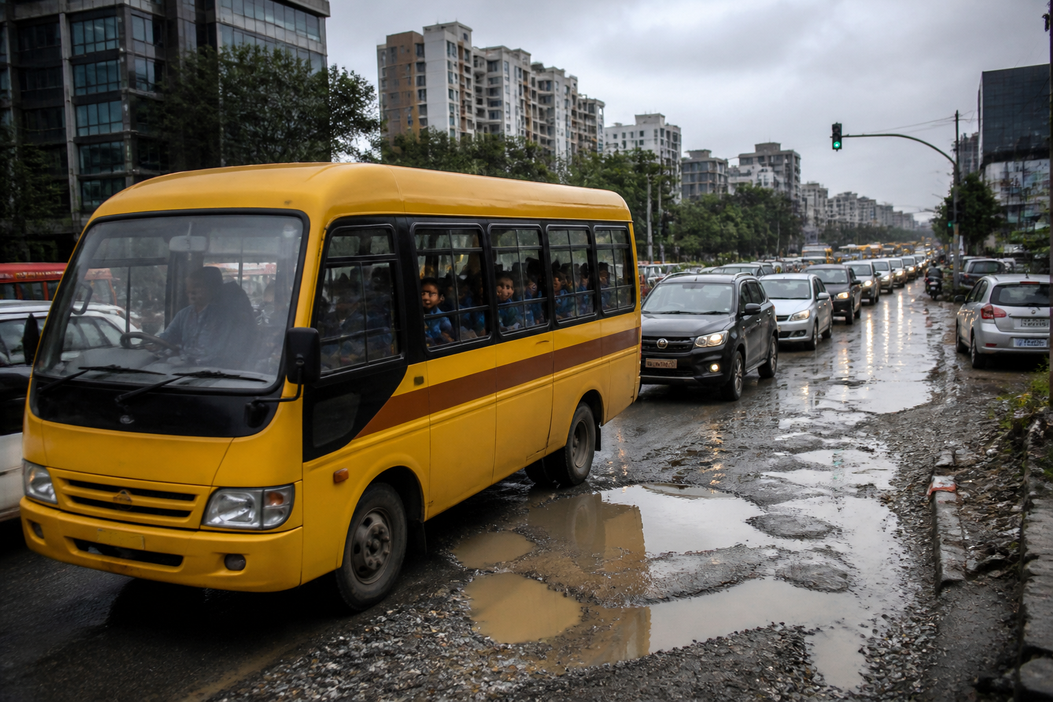
Children travelling to school along Bengaluru’s State Highway 35 corridor are spending so much time in traffic that the equivalent of 53 school days a year is being lost on the road, according to a survey by Inventree Academy. The finding exposes a larger urban problem in eastern Bengaluru: roads serving schools, homes and employment centres are carrying more demand than their current condition and management systems can handle.
The corridor connects Hoskote, Whitefield and Gunjur, with surrounding links towards Anekal. The report says 42 schools operate within the State Highway 35 area and serve more than 40,000 children. The same corridor also contains information technology and biotechnology companies and housing occupied by a large number of employees. As residential and employment activity has expanded, the daily movement of school buses, private vehicles and other traffic has increased.
The result is not simply a longer commute. It is a shift in how the city allocates time. Children leave home earlier, spend more time inside school vehicles and return later, reducing the hours available for rest, study and activities outside the classroom. The survey records a 22% increase over the past two years in the time children spend travelling in school vehicles.
The reported increase is visible across three academic periods. In 2024-25, children were spending 92 minutes in traffic, according to the report. That rose to 102 minutes in 2025-26 and has now reached between 112 and 120 minutes. The figures refer to the time children spend in traffic while travelling to and from school, as described in the report. During the monsoon, the situation can become more severe: vehicles breaking down on the road can leave children stuck for more than three hours.
The survey says that if schools operate for 200 days a year, children spend 374 hours travelling. The report presents this as the equivalent of 53 school days spent on the road. While the precise calculation and survey methodology are not detailed in the supplied material, the direction of change is clear: travel time has risen steadily over the three academic periods identified.
Bengaluru traffic is therefore functioning as an education issue as much as a transport issue. A school corridor is not only a route between homes and campuses. It is a daily public system that must coordinate road quality, traffic enforcement, parking, drainage, waste collection, school timings and the movement of surrounding employment districts. When any one of these systems fails, the cost is transferred to families and children through longer journeys.
The report identifies several immediate causes. Potholes and deteriorated road surfaces slow vehicles and make journeys less predictable. Waste disposal along roadsides reduces usable carriageway space and creates additional obstacles. Unregulated parking constricts the road edge, while violations by motorists increase conflict between vehicles. During rain, water fills potholes and makes them harder to see, adding both delay and risk.
These are familiar forms of urban failure, but their combination is significant. A damaged road alone may reduce speed. Parking alone may narrow a lane. A traffic violation alone may create a short interruption. On a corridor with schools, offices and residential growth, however, the effects compound. A small reduction in road capacity can produce long queues at school-opening and school-closing times, when thousands of children and workers are travelling within similar time windows.
The institutional challenge is that responsibility is distributed. Road maintenance, traffic enforcement, roadside waste management and parking control may involve different agencies or administrative units. The supplied report does not identify a single authority responsible for the entire corridor or provide details of a coordinated intervention. That absence is important because a school commute cannot be improved through road resurfacing alone if parking, waste and enforcement problems continue to reduce capacity.
The corridor’s growth also points to a planning gap. The report links rising traffic to the presence of technology companies, a large employee population and expanding vehicle movement around Hoskote, Whitefield, Gunjur and nearby areas. This means school traffic is being generated inside a wider urban system rather than by schools alone. Housing, offices, private vehicles, school buses and roads are interacting on the same network, but the reported consequences are being experienced most directly by children.
The survey’s figures offer a limited but useful time series. Travel time rose from 92 minutes to 102 minutes and then to 112-120 minutes. Even without additional traffic counts, this sequence indicates that the problem is not being described as a one-day disruption. It is a repeated deterioration in the daily journey. The report also identifies a seasonal escalation during rain, when breakdowns and water-filled potholes can turn an already long trip into a delay lasting more than three hours.
The health concerns described in the report follow directly from this pattern of prolonged travel, though they should be understood as reported risks rather than established findings from the survey itself. Inventree Academy CEO Norain Fazal said children may face adverse effects on their physical and mental health because so much time is spent travelling between home and school. Parents cited concerns about respiratory and allergy-related problems associated with extended exposure to traffic congestion, as well as reduced sleep when children have to wake early.
The report also says that insufficient sleep may be linked to reduced interest in studies and sleep deprivation. These concerns underline why the issue cannot be treated only as a question of traffic speed. A two-hour daily journey changes the rhythm of family life. It affects when children wake, when they return home, how much time they have for recreation and how long they can rest before the next school day. The supplied material does not provide medical data or an independent health assessment, but it does document the concerns being raised by parents and the school leadership quoted.
There is also a question of measurement. The survey identifies a large affected population and provides yearly travel-time figures, but the supplied report does not explain how many children were surveyed, how travel time was recorded, whether the figures represent one-way or round-trip journeys, or how the 53-school-day calculation was made. Those details matter for policy because authorities need a common baseline to determine whether an intervention is working. A corridor-wide assessment would need to distinguish recurring congestion from monsoon disruption, school traffic from office traffic and delays caused by infrastructure from those caused by driving behaviour.
That measurement gap should not obscure the public-interest signal. More than 40,000 children across 42 schools are located within a corridor where road conditions and congestion are reported to be worsening. Even if individual travel times vary, the repeated exposure of school buses to potholes, roadside obstructions and heavy traffic indicates that the education network is dependent on transport infrastructure that is under strain.
The immediate policy landscape is consequently broader than a single road repair project. The problems listed in the report require attention to pavement quality, pothole response, roadside waste, parking management, traffic-rule enforcement and monsoon drainage. They also require coordination between the institutions overseeing roads, traffic, waste and schools. The report does not state that such a coordinated programme is currently in place, nor does it announce a deadline or approved project.
For families, the lack of predictability may be as damaging as the average delay. A journey that usually takes 112 minutes but can extend beyond three hours during a breakdown or heavy rain makes it difficult to plan school arrival, work schedules and childcare. For schools, unreliable access can affect transport operations and the timing of the school day. For the city, it shows how the cost of growth is being absorbed through private time rather than resolved through network planning.
The larger urban question is whether Bengaluru’s expanding employment and housing corridors are being matched by the basic mobility systems that connect them. State Highway 35 is serving schools, offices and residential areas at the same time. Its problems illustrate how a road can become a critical social infrastructure corridor without receiving the management attention required by that role.
The evidence supplied confirms a worsening reported trend in school travel time and identifies the physical and behavioural factors that contribute to it. It does not establish the precise share of responsibility held by each agency or independently verify the health effects described. The next meaningful developments would be a published corridor assessment, transparent survey methodology, road and traffic data, and any official timetable for repairing the affected routes and managing parking, waste and enforcement around the schools.
