


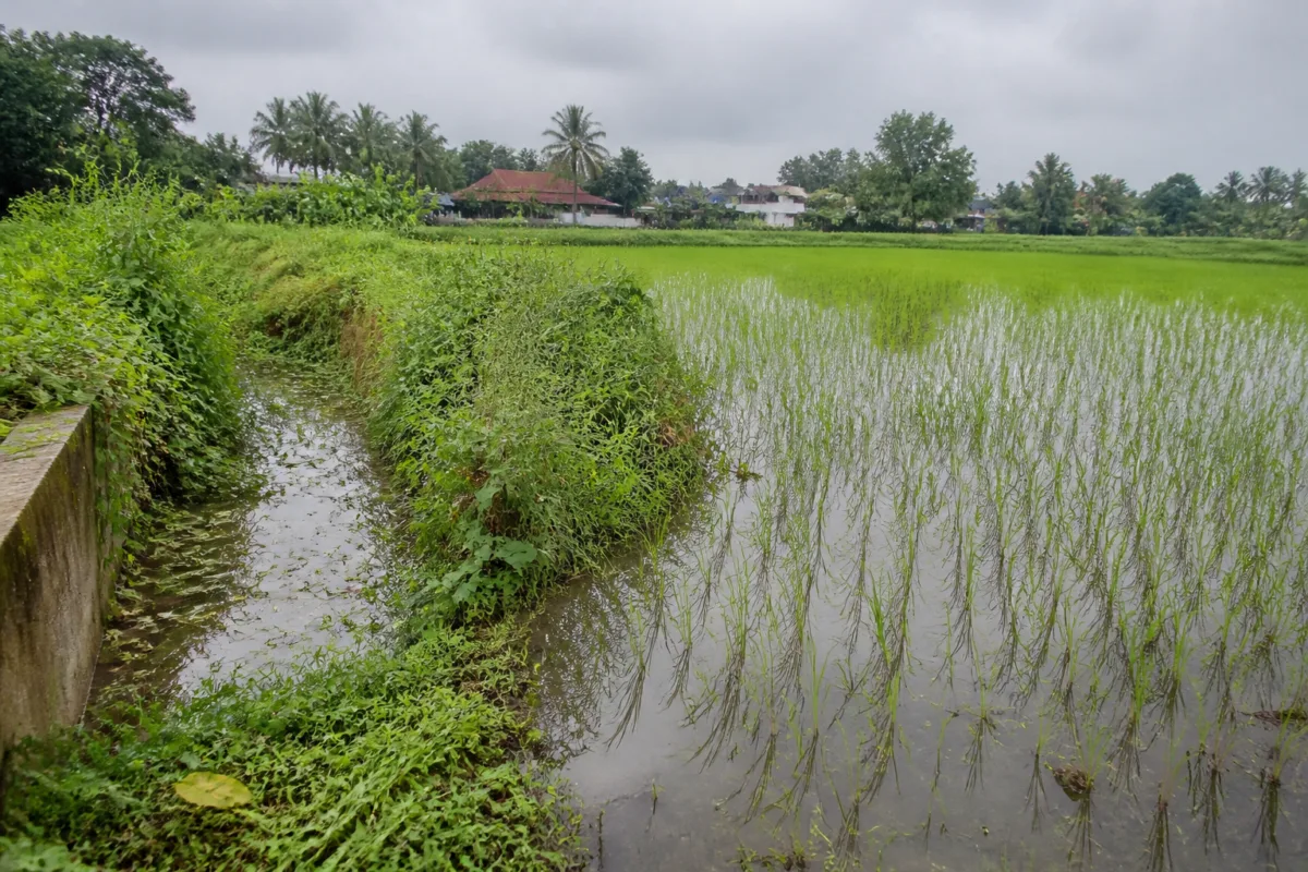
Rice planting has begun in the Parakkadavu-Poovathussery paddy fields in Kerala’s Ernakulam district, but farmers are once again watching the drainage channels rather than the crop. Intermittent heavy rain has already caused waterlogging in parts of the fields, raising fears that newly planted seedlings could rot if the water does not recede. The immediate concern points to a larger problem: a protected agricultural landscape depends on a network of channels whose maintenance determines whether farming can continue at all.
The Parakkadavu paddy fields cover about 500 acres, of which around 250 acres are under continuous paddy cultivation. Around 200 farmers, organised through two rice-producer committees, cultivate the area. The fields are described as fertile and capable of good production, but waterlogging has reduced the agricultural cycle from the three crops once grown there to a single crop a year.
For several years, farmers have followed a cycle in which cultivation begins in October and harvesting takes place in March. The current planting began after the previous harvest was completed in March. Farmers raised seedlings using 5.5 tonnes of Ponmani seed supplied for cultivation. Their anxiety is based on recent experience rather than a temporary weather disruption. Two years ago, waterlogging destroyed the entire crop in the paddy fields.
The drainage system consists of the Elathodu, Vazhar Thodu and Aluvathodu channels, which carry water towards the Chalakudy river. The channels are approximately 2.5 kilometres, three kilometres and 3.5 kilometres long respectively, according to the report. Their combined function is central to the fields’ water balance: they must remove excess rainwater while also supporting the movement of water needed for cultivation.
That balance has been weakened by vegetation and the failure to clean sections of the channels. Farmers say the Vazhar Thodu is overgrown in several places, preventing water from flowing out of the paddy fields towards the river. The problem is therefore not simply the amount of rain. It is also the condition and continuity of the route through which that water is expected to leave.
The issue shows why drainage infrastructure in agricultural areas cannot be treated as a seasonal clearing exercise. A channel may appear functional in one stretch while an overgrown section downstream prevents the entire network from performing. In Parakkadavu and Poovathussery, the three channels are connected in sequence, meaning that a blockage or narrowed passage can affect water movement across the wider paddy landscape.
The farmers’ recent experience also shows the difference that maintenance can make. After repeated demands from farmers, the three channels were cleaned under the Operation Vahini project. The work enabled cultivation to resume in October last year, and farmers received a good harvest in March. However, the channels became overgrown again after rain following the harvest. The present planting season has therefore begun with the same infrastructure concern returning.
This pattern creates an administrative problem as much as an engineering one. The fields lie in an area connected to Parakkadavu and Kuzhur panchayats and close to the Ernakulam-Thrissur district boundary. Drainage does not stop at an administrative border, while responsibility for maintenance can become divided between local bodies and other authorities. Farmers and residents are consequently seeking timely cleaning of all three channels rather than isolated work on one section.
The consequences extend beyond agriculture. Around 100 nearby homes reportedly face recurring water entry when the paddy fields remain waterlogged. This makes the drainage network a shared piece of local infrastructure: it protects crop production, reduces pressure on residential areas and helps preserve a landscape that has been designated for paddy cultivation. When the channels fail, the costs are distributed across farmers, households and local authorities.
Farmers are also seeking a more permanent intervention in the form of a 750-metre boundary canal along the six-foot-wide pathway on the Ernakulam-Thrissur border, where boundary markers were previously installed. The proposed channel would begin near the point where the Elathodu and Vazhar Thodu meet and run towards the Kochukadavu ferry point on the Chalakudy river. A section would pass beside the Aluva-Eramathur road and would need to cross the road.
The proposed canal is intended to create a more direct route for removing water from the paddy fields. Farmers say it could benefit cultivators in Kuzhur as well and potentially make it possible to return to three-crop farming if waterlogging is fully controlled. They have also proposed placing slabs over the canal so that it can function as an access route to the fields. A shutter at the Kochukadavu ferry point has been suggested to prevent river water from flowing back into the canal when the Chalakudy river rises during the monsoon.
These proposals reveal that the dispute is not about one missing cleaning operation alone. Farmers are asking for two different layers of intervention: regular maintenance of the existing channels and a new piece of infrastructure that could improve the drainage system’s capacity and control reverse flow. The first addresses the immediate loss of function caused by vegetation. The second addresses the network’s longer-term design and its relationship with the river.
The history of the fields makes the stakes clearer. About 25 years ago, the area supported three-crop cultivation. Over time, waterlogging and neglected channels reduced that agricultural intensity. The failure of the drainage routes contributed to crop losses and farmer hardship, while nearby households experienced recurring flooding. The recovery after last year’s cleaning demonstrates that the land has not lost its productive potential; the constraint is the reliability of the water-management system around it.
The evidence supplied in the report does not establish the cost, technical design, land-acquisition requirements or responsible agency for the proposed boundary canal. It also does not provide a formal response from the relevant panchayats, district administrations or irrigation authorities on when the three channels will be cleaned. Those details will determine whether the demand becomes an implementable project or remains a local proposal.
What is established is that cultivation has restarted under continuing drainage risk, despite a successful cleaning operation last year. The Parakkadavu-Poovathussery fields therefore offer a clear example of how urban and peri-urban resilience depends on ordinary infrastructure that is easy to overlook: open channels, road crossings, river outlets and local maintenance schedules. The next test will be whether the authorities can keep all three channels functioning through the cultivation season and examine the proposed boundary canal before the next cycle of heavy rain exposes the same weakness again.

