


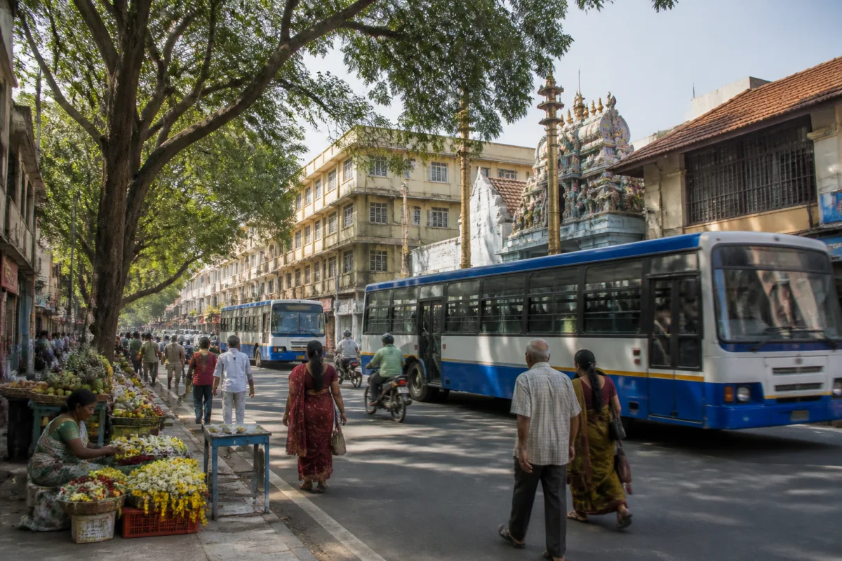
B.M. Srikantaiah Road is more than a named street in south Bengaluru. Linking Basavanagudi and Hanumanthanagar, it brings together older residential neighbourhoods, temples, educational institutions, local markets, public transport and green public spaces. Its importance lies not in a single landmark or infrastructure project, but in the way an established urban road continues to connect several layers of city life.
The road is being highlighted during Karnataka Rajyೋತ್ಸವ celebrations in recognition of B.M. Srikantaiah, the Kannada scholar widely known as B.M. Sri. The road carries his name through one of the older and culturally significant parts of Bengaluru. The source report describes it as a major route connecting Hanumanthanagar, Basavanagudi, Kempegowda Nagar, N.R. Colony, Girinagar, Srinivasanagar and the Vidyapeetha Circle area.
This geography explains why the road functions as an urban connector rather than merely a neighbourhood street. It links places that serve different purposes: residential areas, religious destinations, schools and colleges, small shops, bus routes and nearby metro stations. In a rapidly expanding city, such streets often provide the everyday connections that large infrastructure projects do not fully replace.
The road’s institutional landscape is unusually dense. The report identifies several religious and cultural destinations near the route, including the Ram Anjaneya Swamy Temple, popularly known as Gudda Anjaneya Swamy Temple, the Dodda Ganapathi Temple, the Ramakrishna Ashram, the Sri Mallikarjuna Swamy Temple, the Karanji Anjaneya Temple, Uttaraadi Math, Sringeri Shankara Math, Poornaprajna Vidyapeetha, the Magadi Karanikara Pathashala, Sri Vyasaraja Matha Sosale, Raghavendra Swamy Brindavan, Puthige Matha, the Renukamba Temple and the Jayatirtha Brindavan institution.
These destinations give the road a function that is broader than traffic movement. They create recurring pedestrian and visitor activity and connect the street to the cultural memory of old Bengaluru. The source material also places the road near M.N. Krishna Rao Park and other green areas, reinforcing the contrast between a busy urban corridor and the tree-filled neighbourhood character associated with Basavanagudi and Hanumanthanagar.
The road’s role is equally visible in its commercial activity. Grocery shops, bakeries, clothing stores and flower and fruit vendors line both sides, according to the report. These are not destination retail formats designed around large developments. They are everyday businesses serving nearby households, students, workers, visitors and commuters. Their presence indicates how older streets can function as distributed neighbourhood markets, where daily needs are met within walking distance or a short local trip.
That pattern matters for understanding how established parts of Bengaluru operate. A city is not held together only by arterial roads, flyovers and mass-transit corridors. It also depends on streets that combine movement with access: access to food, education, worship, small businesses, parks and social institutions. B.M. Srikantaiah Road performs this combined role across a compact urban area.
Public transport adds another layer. The report states that BMTC buses connecting Kempegowda Bus Station, commonly known as Majestic, and K.R. Market with Hanumanthanagar and Srinagar use the road. This places the street within a wider public transport network linking south Bengaluru to two important city destinations. The route is therefore relevant not only to residents living along it but also to passengers travelling between market, commercial and neighbourhood areas.
The road is also close to the National College and Lalbagh stations on the Green Line of Namma Metro. The source does not provide passenger numbers, journey times or traffic counts, so it is not possible to measure the road’s transport performance from the available material. But its proximity to metro stations shows how older surface streets and newer rapid-transit infrastructure overlap. Metro stations provide high-capacity movement along a fixed corridor, while connecting roads distribute passengers into surrounding neighbourhoods and institutions.
This relationship between mass transit and local streets is central to how cities function. A metro station cannot serve an area in isolation. Passengers need roads, footpaths, buses, crossings and local destinations around the station. In B.M. Srikantaiah Road’s case, the surrounding mix of schools, temples, shops and housing creates multiple reasons for people to use the area throughout the day. The road’s urban value comes from this network of uses rather than from transport alone.
Education is another major component of the corridor. The report lists institutions including B.M.S. College of Engineering, B.M.S. College for Women, National College, Bengaluru Higher Secondary School, V.E.T. School, Acharya Pathashala, Bengaluru Institute of Technology, Vijaya College, V.V. Puram College, Vasavi Vidya Niketan, Surana College, The Home School, B.B.U.L. Jain Vidyalaya, Atmashree Vidya Samsthe, Mookambika Vidya Samsthe, Sri Lalitha Vidya Mandir and the Indian Institute of World Culture.
The presence of these institutions means the road serves a large daily population beyond permanent residents. Students, teaching staff, support workers, parents and visitors add to its mobility needs. Schools and colleges also make the quality of the street environment significant: the road is not simply carrying vehicles between two points but supporting repeated trips to educational and cultural destinations.
At the same time, the surrounding neighbourhoods retain the character of older Bengaluru. Basavanagudi and Hanumanthanagar are described in the source as areas with traditional residential patterns and a strong cultural identity. Their urban form is represented through temples, parks, local commerce, mature greenery and houses that reflect an earlier phase of the city’s development. The road sits within this inherited landscape while also serving modern transport requirements.
Bugle Rock is one of the area’s most visible historic and ecological landmarks. Located in Basavanagudi, it is associated with one of the watchtowers traditionally attributed to Kempe Gowda, the founder of Bengaluru. The rock formations near the Bull Temple, the stone steps and the elevated view of the surrounding area make it both a heritage site and a public open space. The report also notes the presence of varied trees, bats and birds in the area.
This combination of heritage and greenery gives the corridor an urban identity that cannot be reduced to its road width or traffic function. Public spaces such as Bugle Rock and M.N. Krishna Rao Park help preserve ecological and cultural features within a dense, established part of the city. Their value is particularly visible in neighbourhoods where redevelopment pressure and changing commercial activity can otherwise weaken local identity.
The evidence supplied in the report does not establish how the road is managed, whether it has dedicated pedestrian facilities, how traffic congestion has changed, or what conservation measures apply to its landmarks. It also does not provide information on road safety, parking, street vending regulation, footpath conditions or the impact of metro access on local businesses. Those questions would require municipal records, transport data and on-ground reporting.
What the available evidence does establish is that B.M. Srikantaiah Road serves several urban systems at once. It is a public transport route, a local market, an institutional corridor, a religious and cultural access road, and part of a historic residential landscape. Each function brings different users and operating needs. The road’s significance therefore comes from its layered use, not from one isolated project or announcement.
The larger urban question is how Bengaluru can retain the social and cultural value of older streets while keeping them functional for contemporary mobility. Roads such as this one carry the memory of the city, but they also carry buses, students, workers, shoppers and visitors every day. Treating them only as traffic corridors would overlook their role as public platforms; treating them only as heritage spaces would overlook their transport and economic importance.
B.M. Srikantaiah Road illustrates the connective tissue of established Bengaluru. Its temples, colleges, shops, parks, homes, bus services and metro access form a system that residents experience as one neighbourhood, even though it contains many different institutions. The supplied report confirms the breadth of that role. It also shows why the future of such streets must be understood through their combined cultural, social, commercial and mobility functions rather than through road infrastructure alone.

