


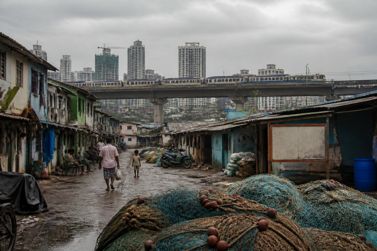
Dharavi Koliwada’s reported 400-year history is colliding with a modern urban system that often recognises settlements through mapped residential structures rather than through their social, occupational and cultural geography. The dispute matters because the Koliwada is not only a cluster of homes beside the Dharavi redevelopment area; it is a historic fishing community whose identity, boundaries and relationship with the Mithi River have shaped this part of Mumbai for generations.
A report by Loksatta – Mumbai traces references to Dharavi Koliwada to historical gazetteers and surveys conducted during the British period. It says that 93 Koli families were recorded in the settlement in 1784, while references also appeared in Captain Thomas Dickinson’s 1812 survey, Colonel Lawton’s 1860 survey and a British survey conducted in 1912. These records are central to the community’s argument that Dharavi Koliwada existed as an established settlement long before contemporary redevelopment plans.
The significance of those records extends beyond history. In a redevelopment process, the way a place is defined determines what is counted, what is protected and who is considered eligible for recognition. The report says the Koli community has opposed attempts to include the Koliwada in the neighbouring Dharavi project. It also describes an alleged subsequent effort to isolate the settlement by questioning whether it existed as a distinct village or gaothan. The account is based on the report and statements attributed to representatives of the Dharavi Koliwada Jamati Trust.
The disagreement appears to involve a basic difference in how urban space is measured. The report says that an external boundary survey in 2018 measured the Koliwada at approximately 200,000 square metres. After a meeting with Maharashtra Revenue Minister Chandrashekhar Bawankule, it was reportedly decided that another survey would identify the boundary up to the last house. The report says that this survey’s findings had not been released at the time of publication.
The same report refers to private letters held by the Dharavi Redevelopment Authority when the authority began operating in 2008. According to the report, those letters referred to 43,000 square metres as the Koliwada’s settlement area, while the authority later showed 23,000 square metres as inhabited settlement. The difference is not a minor cartographic detail. It illustrates how a community can be reduced from a historic settlement with common institutions, workspaces and shared land relationships to a narrower calculation of occupied homes.
That distinction is particularly important for a fishing community. A Koliwada’s physical and social geography cannot be understood only through housing footprints. Its identity is connected to access routes, water, communal spaces, occupational areas, religious and cultural practices, and institutions that regulate community life. The Loksatta report describes the Dharavi Koliwada as an urban village of the Koli fishing community and records the presence of a community trust, a panchayat and a patil. It says that decisions taken through the community’s assemblies and trust are treated as binding within the settlement.
The account also records a shared social identity across religious lines. The report says that Christian residents form a significant part of the Koliwada but continue to identify as Koli, while Hindu and Christian residents participate together in festivals and community events. It identifies the community’s patil as Christian and notes that the trust includes people who serve as panchs. These details show that the Koliwada’s continuity is institutional as well as physical: its history is carried through local governance, collective decision-making and shared cultural participation.
The settlement’s relationship with water has also changed sharply. Dharavi is located where the Mithi River ends, and the report links the area’s earlier economic life to salt trading and fishing. It says that the sea once reached the Koliwada and that a wall was built in 1920 to hold back seawater. The T-junction at what is now the Dharavi-Sion junction was earlier a creek, according to the report. This history places the Koliwada within Mumbai’s altered coastal landscape, where roads, land reclamation, flood-control infrastructure and transport projects have progressively reshaped former waterways and tidal edges.
The report says that fishing was once the community’s principal livelihood, with large catches available in the Mithi River and surrounding waters. It also says that pollution in the river and the construction of a sea link have made fishing more difficult. Residents nevertheless continue to take boats to sea, using larger boats during high tide and smaller boats at other times. The details point to a wider urban contradiction: infrastructure can improve regional connectivity while simultaneously changing the ecological and economic conditions on which older settlements depend.
Transport infrastructure has been part of this transformation for decades. The report says a rough road connecting the area to Kalanagar in Bandra was built in 1970, followed by a paved road in 1980 linking Sion-Dharavi with the western suburbs. The location now also includes the Dharavi station of the Aqua Metro railway. These changes have made the settlement more connected to Mumbai’s metropolitan network, but connectivity alone does not establish whether an old community’s land, livelihood and cultural spaces will be retained through redevelopment.
Historical payment records are another part of the community’s evidence. The report says that the community paid fees required for fishing between 1927 and 1964, with receipts carrying the description “Hindu Christian Fishermen Water Tax”. Such documents do not, by themselves, settle present-day boundary or redevelopment questions. They do, however, provide evidence of an organised community whose relationship with the water and the administration was documented over time.
The institutional question is therefore not simply whether Dharavi Koliwada appears on a current map. It is which map is being used, what purpose it serves and whether the map records the full settlement. A plan focused on inhabited structures may produce a smaller footprint than a boundary survey that includes communal grounds, access routes, historic occupational areas and other spaces necessary to the functioning of a village. The report specifically quotes Dharavi Koliwada Jamati Trust secretary Digambar Koli arguing that a village or gaothan cannot be defined as only its residential houses.
This is also where redevelopment policy meets the limits of administrative categories. A large urban project requires clear boundaries, land records and eligibility lists. Communities, by contrast, often operate through layered forms of belonging that include occupation, customary institutions, historic records and collective spaces. When these layers are not reflected in the survey process, the administrative definition can become narrower than the community it is intended to regulate.
The supplied report does not establish the final legal status of the Koliwada’s boundaries, the outcome of the proposed resurvey or the precise treatment of the settlement in the current Dharavi redevelopment plan. It also does not provide the underlying survey documents or the authority’s response to the differences in recorded area. Those remain important unresolved parts of the story.
What the available evidence does establish is that Dharavi Koliwada’s redevelopment dispute is rooted in more than resistance to a neighbouring project. It concerns whether Mumbai’s planning and redevelopment institutions can recognise a historic urban settlement as a living social and economic system. The next significant development will be the release of the promised boundary survey and the clarification of how the Koliwada is represented in official redevelopment records. Until then, the gap between historical evidence, community identity and administrative mapping remains the central urban question.
