


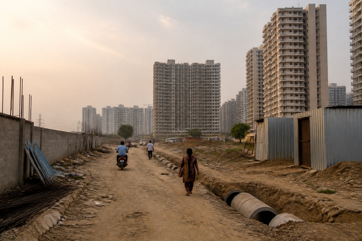
Haryana’s decision to compulsorily acquire 1,157.22 acres of private land for missing 24-metre roads in Gurugram is more than a delayed infrastructure announcement. It is an admission that the city’s expansion outpaced the institutional system meant to connect its new residential sectors. The proposed acquisition covers 63.01% of the land required for internal road alignments across sectors 58 to 115 of the Gurugram-Manesar Urban Complex, while the state has not set a completion date for the full exercise.
The issue reached the Punjab and Haryana High Court through petitions concerning stalled sector roads. In a hearing on September 14, the court observed that the situation had remained largely unchanged since licences for several projects were granted more than a decade ago. It noted that the absence of roads was compelling some homebuyers to seek refunds and discouraging people from living in affected housing societies. The court then directed the Advocate General of Haryana to assist it and gave the state a final opportunity to submit an actionable plan with specific timelines.
The Department of Town and Country Planning’s status report, submitted to the court on September 22, divides the missing road network into three categories. Of the 1,836.6 acres identified for 24-metre road alignments, 1,157.22 acres is unacquired private land. The government now proposes to acquire this land compulsorily under the Right to Fair Compensation and Transparency in Land Acquisition, Rehabilitation and Resettlement Act, 2013.
A further 574.4 acres, or 31.28% of the alignment, lies within licensed colonies. Developers are legally required to construct these roads and hand them over to the government free of cost before obtaining completion certificates under the Haryana Development and Regulation of Urban Areas Act, 1975. Another 104.98 acres has already vested with the government through Transferable Development Rights certificates.
These figures show that the problem is not simply a shortage of road construction. It is a land assembly problem embedded in the way Gurugram’s private development was approved. Developers could build roads within their licensed plots, but they could not acquire the intervening private agricultural land needed to create continuous internal connections between sectors. The result was a city where housing projects could be completed inside individual sites without the surrounding network being assembled at the same pace.
The most severe gaps are concentrated in areas that have seen major residential development. In sectors 99 to 115 along the Dwarka Expressway, nearly 70% of the required road alignment remains unacquired. The unacquired share is 68.67% in sectors 68 to 80 and 65.15% in sectors 88 to 95B. These numbers indicate that the missing links are not isolated pockets but a repeated pattern across several large urban growth areas.
The historical reason for the gap lies partly in the treatment of internal roads under Haryana’s development-finance system. Internal 24-metre roads were historically not covered under External Development Charges. Haryana Shehri Vikas Pradhikaran used EDC funds to acquire land for 60-metre and 75-metre master sector roads, but there was no comparable mechanism to assemble private land for the smaller roads cutting across intervening agricultural parcels.
That distinction created a mismatch between the formal road hierarchy and the lived geography of the city. Wider master roads could be planned and funded through a state-linked mechanism, while the shorter roads required to reach individual housing societies remained dependent on fragmented private ownership and developer-level obligations. A residential project could therefore receive approvals and proceed with construction even when the wider network needed to connect it to neighbouring sectors was incomplete.
In several locations, temporary occupation certificates were obtained through informal rights-of-way, dirt tracks or leased land arrangements with local villagers. Such arrangements could provide access while construction was under way, but they did not create permanent public infrastructure. After housing societies were built, some landowners reclaimed their parcels by erecting boundary walls and tin sheds or digging trenches. The consequences extended beyond road access: residential societies were also left without proper routes for sewer and water pipelines.
This sequence reveals the institutional weakness at the centre of the dispute. Temporary access was treated as a workable substitute for legally assembled, serviceable roads. But a temporary arrangement has no guarantee of continuity once land values rise, ownership interests change or a private agreement ends. The court’s intervention has brought that difference into focus by linking the roads problem to the ability of residents to occupy and use completed housing projects.
The state’s 2021 Transferable Development Rights policy was expected to help address land assembly, but the DTCP told the court that applying for TDR remained voluntary for landowners. That limitation left the policy unable to resolve situations where a small number of parcels blocked an entire road alignment. Without a compulsory mechanism or a reliable funding structure, the road network remained dependent on individual participation.
The government’s current approach changes that position by using compulsory acquisition. The move follows an announcement in the state Budget earlier this year by Chief Minister Nayab Singh Saini. Administrative approval was granted on September 15, and a Joint Site Inspection Committee was formed two days later to conduct surveys and revenue verification. Its report, finalised on September 21, recommended a pilot acquisition of 10.611 acres across sectors 81, 82, 82A, 83, 84, 85, 86 and 104.
The pilot covers seven pockets accounting for 3.65 acres in Sector 104, along with stretches in sectors 84 and 85. The DTCP told the court that this initial acquisition would be funded from its available EDC reserves. A separate financial mechanism is to be worked out for the remaining land, which means that the pilot and the full 1,157.22-acre exercise do not yet have the same funding certainty.
Notifications for the acquisition process were published in newspapers on September 30. However, the department said it could not provide a fixed date for completing the acquisition of the entire unacquired area. It cited the scale of the exercise, the involvement of multiple agencies, revenue verification and the need to deal with hundreds of landowners.
That absence of a deadline is significant because the court’s concern is not only whether the state has identified the land. The central question is whether identification can be converted into a connected and usable road network. Land acquisition, compensation, possession, construction and the laying of utility lines are separate administrative steps. A status report can establish the extent of the gap, but it cannot by itself resolve the sequencing problem between them.
The case also exposes the limits of measuring urban development through project-level approvals. Developers may satisfy the conditions applicable to their licensed plots, but residents experience the city through the connections between those plots: the road to the main sector route, the route for emergency services, and the infrastructure corridor carrying water and sewer lines. When those links are missing, a completed housing project can remain functionally incomplete.
The numbers submitted to the court make the scale of the problem difficult to treat as a localised dispute. Nearly two-thirds of the identified alignment is on unacquired private land, while almost one-third lies within licensed colonies where developers have construction obligations. The state therefore has to address two distinct failures at once: assembling land outside licensed plots and enforcing or completing roads within the licensed development areas.
For residents, the practical consequences are immediate. Access can depend on temporary tracks, private arrangements or roads that stop at the edge of a housing project. The same missing connections can delay sewer and water infrastructure, increase dependence on longer routes and make the physical completion of a society different from its legal or construction completion. The High Court’s reference to refund demands and reluctance to live in affected societies indicates that the infrastructure gap is also affecting the usability and credibility of housing delivered in these sectors.
The larger urban question is whether Gurugram’s development framework can align land assembly, road construction and building permissions before new projects are occupied. The present response is attempting to correct a backlog created over more than a decade. Its success will depend on how quickly the pilot moves from survey to acquisition and construction, how the remaining land is financed, and whether responsibilities for developers and public agencies are clearly enforced.
The evidence currently confirms the scale of the missing network, the legal route selected by the state and the first sites identified for acquisition. It does not establish when the full 1,157.22 acres will be acquired or when all 24-metre roads across sectors 58 to 115 will become operational. Those milestones, along with the court’s further consideration of the state’s action plan, will determine whether Gurugram’s roads crisis is being structurally resolved or merely documented again.
