


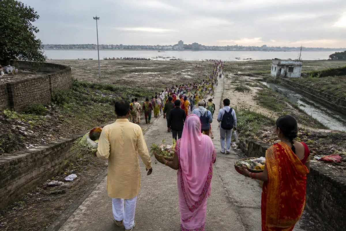
The Patna Ganga shift is changing how residents reach the river, with Chhath devotees walking longer distances to offer arghya at ghats that were once closer to the city. The change, reported over the past 10 to 15 years, is not only a religious-access issue. It is also a visible indicator of how river movement, urban construction, drainage and floodplain management intersect in a growing city.
The immediate evidence comes from the experience of residents who continue to visit the Ganga despite the increasing distance. Devotees say the river remains preferred because of its religious significance, even when other waist-deep water bodies could technically serve the ritual. The number of people visiting the ghats is also reported to be rising each year, increasing pressure on access routes and riverfront facilities.
For Patna, this creates a difficult planning problem. A city can respond to a shifting river by extending roads, adding temporary access arrangements or creating new facilities closer to where water is available. But each intervention can have consequences if it is planned without understanding the river’s channels, sedimentation, drainage paths and floodplain limits. The report’s central question is therefore not simply where devotees should stand during Chhath, but how the city should build around a river that does not remain fixed.
The change is particularly clear at Collectorate Ghat. Manoj Mittal, a resident living nearby, recalled swimming there with his brothers a few years ago. He said the ghat has since turned into a nullah. His account links the larger movement of the river to a ground-level loss of access: a place remembered as a riverfront location is now experienced as a drain-like space.
That transformation matters because ghats are not isolated platforms. They are points where the city meets the river, and their condition reflects the relationship between urban land, water movement and public use. When a ghat loses direct contact with the river, residents are pushed towards other locations. During a major festival, that shift can turn into longer walks, more concentrated crowds and greater dependence on roads and temporary arrangements.
The report also shows that residents distinguish between ritual requirements and cultural preference. Ashutosh Kumar of Gola Road said Ganga water was not essential for offering arghya because any place with waist-deep water could be considered suitable. Yet he continued to prefer the Ganga and said he had visited its ghats since childhood. This distinction is important for planning: the city may be able to provide water elsewhere, but alternative sites do not automatically replace the social, cultural and historical significance of the river.
The infrastructure question is equally significant. Development professional Eklavya Prasad said growth near the Ganga should be assessed against ecological, hydrological and floodplain requirements. Roads, sewage works, water facilities and private construction may serve public purposes individually, but their cumulative impact requires examination. The concern is that separate projects can collectively alter drainage, reduce open space or obstruct the paths through which water moves.
Prasad called for satellite imagery, old maps and field studies to establish how channels, sedimentation, water flows and floodplain limits have changed. This proposed evidence base is important because the available accounts describe the outcome of change more clearly than its precise cause. The report records that the river has shifted farther from the city, but it does not establish which specific construction activity, intervention or natural process produced the shift.
That distinction should shape the policy response. A riverfront plan based only on the current location of water may solve access at one ghat while creating problems elsewhere. A study of historical maps and satellite imagery could show whether the shift is part of a broader change in the river’s course, a consequence of sediment deposition, the result of altered channels or a combination of factors. Field investigations would then be needed to test how these changes affect drainage and floodplain behaviour on the ground.
The report’s warning against relying on temporary dredging also points to a recurring institutional challenge. Dredging may create short-term access or alter the appearance of a ghat, but it does not by itself provide a durable understanding of the river’s movement. Prasad argued that ghats need sound engineering solutions and that the river’s space must be respected throughout the year, not only during Chhath.
This is where festival planning and year-round urban governance meet. Chhath makes the access problem highly visible because large numbers of devotees reach the river within a limited period. However, the underlying questions concern everyday infrastructure: where sewage and stormwater go, whether roads obstruct natural drainage, how construction is permitted near the floodplain, and which agency is responsible for maintaining safe and usable river access.
Former Patna University teacher Jayadeva Mishra proposed barricading the Ganga to control its flow and stabilise its course. He also suggested using deposited silt and mud to improve farmland and urged government authorities to examine the river’s flow from Hajipur through Patna to Simaria Ghat in Begusarai. These proposals indicate that the relevant planning geography extends beyond a single city ghat. River behaviour across connected stretches can influence what happens at Patna’s waterfront.
At the same time, the suggestions in the report remain proposals rather than established government plans. The supplied material does not identify an official ecological assessment, a notified floodplain boundary, a confirmed engineering project or a government timeline for a permanent solution. That absence is significant. Without a common evidence base, different interventions may address isolated symptoms while leaving the broader river system poorly understood.
The Patna Ganga shift therefore exposes a gap between urban infrastructure planning and river management. The city’s immediate need is practical: devotees require safe and accessible places to offer arghya, while residents need reliable roads, drainage and water facilities. The longer-term administrative task is to ensure that these facilities do not narrow the river’s space or obstruct the drainage systems that protect the city.
What the evidence confirms is that access to the Ganga has become more difficult for Patna residents, that the river has moved farther from the city over 10 to 15 years, and that the pressure on ghats is increasing as visitor numbers rise. What remains unestablished is the precise combination of hydrological, ecological and construction-related factors responsible for the change. The next meaningful step would be the comprehensive assessment proposed in the report, covering historical maps, satellite imagery, field conditions, sedimentation, water flows and floodplain limits before permanent ghat or riverfront solutions are adopted.

