


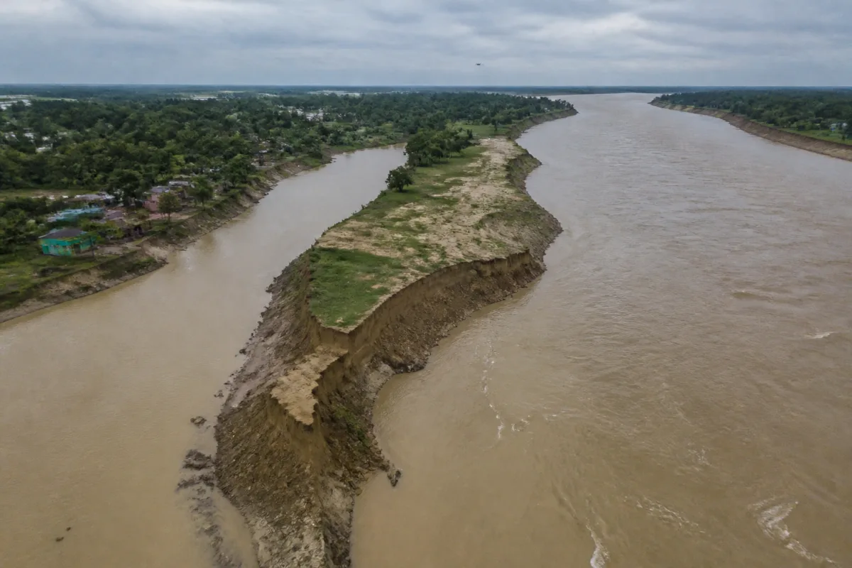
Malda’s river erosion crisis has moved from a recurring district-level emergency to a wider infrastructure and intergovernmental challenge. The warning from Bengal chief secretary Manoj Agarwal that the Ganga and Fulhar rivers could converge near Bhutni and Ratua brings into focus a threat that extends beyond farmland and settlements: extensive flooding could disrupt rail and road links connecting north Bengal with the rest of Bengal and neighbouring states.
Agarwal’s inspection of flood- and erosion-hit areas on Sunday came ahead of a meeting in Delhi on October 27, where chief minister Suvendu Adhikari is scheduled to discuss a permanent solution with the Union water resources ministry. The proposed response involves river dredging, erosion-prevention works, possible sluice gates and a dam-related intervention on the Kosi. Each measure, however, depends on coordination across state boundaries and on an administrative system capable of maintaining river infrastructure over time.
The immediate concern is the changing physical relationship between the Ganga and the Fulhar. During an aerial survey, Agarwal inspected Bhutni islet in Manikchak block, Ratua-I block and the channels of the Ganga, the Fulhar and the Kosi. He said the Ganga near Bhutni had shifted nearly 6km over five decades, while erosion along the Fulhar had pushed that river nearly 2km in the opposite direction.
Those figures, as cited by the chief secretary, explain why the issue cannot be treated simply as another monsoon flood response. The two rivers are described as narrowing the gap between them in the Bhutni and Ratua areas. Agarwal said that a future convergence could make it difficult to prevent floods in Malda. The concern is not only the volume of water entering vulnerable areas, but also the possibility that a changing river course could damage transport links and interrupt regional connectivity.
The proposed intervention also reveals the administrative complexity of the problem. The state government plans to begin erosion-prevention work near the interstate river boundary adjoining Bihar and Jharkhand, about 16km from Manikchak. It has been proposed that old channels through which the Ganga previously flowed in the neighbouring states be dredged to divert water and reduce pressure on vulnerable stretches in Malda.
That plan cannot be implemented by West Bengal alone. Agarwal said Bihar had issued a no-objection certificate for the erosion-prevention work, while clearance from Jharkhand was still awaited. The need for these permissions illustrates how river management follows hydrological systems rather than state boundaries. A project intended to reduce pressure in Malda may require work in, or have consequences for, areas administered by other states.
The first phase of the proposed work is estimated to require ₹50 crore. The figure gives the plan an initial financial scale, but the supplied report does not establish the complete funding structure, the source of the money, the scope of the dredging contract or the maintenance cost after construction. Those details will be important because river interventions are not one-time civic works. Their performance depends on whether channels remain functional, embankments are monitored and changing river behaviour is tracked after implementation.
The state is also examining a proposal for a dam and sluice gates on the Kosi in Bihar to help moderate flooding in Malda. River experts are involved in preparing a pilot project, while construction of concrete embankments has been proposed from January. The report does not provide the design capacity, location, environmental assessment, land requirement or operating authority for the proposed dam and sluice system. It is therefore possible to identify the direction of the proposed response, but not yet assess whether the measures will deliver the permanent solution being sought.
The institutional chain is already visible. The chief secretary held a meeting at the Malda collectorate with district magistrate Rajanvir Singh Kapoor, superintendent of police Anupam Singh and officials from the departments concerned. A second meeting included minister of state for irrigation Joyel Murmu, Manikchak BJP MLA Gour Chandra Mandal and other legislators. The sequence shows that river erosion is being handled simultaneously as a water-management issue, a district-administration issue and a connectivity and public-safety issue.
It also shows why accountability will be difficult to separate from coordination. The inspection followed an aerial assessment and meetings with local officials and elected representatives, but the eventual work will require decisions at multiple levels: district implementation, state irrigation planning, inter-state consent and Union-level coordination. Any delay in one part of that chain could affect the timing of the others.
The political exchange reported after the meetings adds another layer. Mandal accused the previous Trinamool government of corruption in embankment construction and alleged that public money had been wasted while residents continued to suffer. District Trinamool leader Biswajit Ghosh rejected the allegation and blamed inadequate support from the Centre, while saying that the state had continued erosion-prevention work through its irrigation department.
These allegations are not independently established in the supplied report. Their significance lies in showing that the question of responsibility is already competing with the question of engineering. The future design and financing of the work will have to be accompanied by clear records of contracts, approvals, expenditure and performance if the permanent-solution proposal is to be assessed beyond political claims.
The data cited by Agarwal presents Malda’s problem as a long-term movement of river channels rather than a single season’s flood event. A shift of nearly 6km in the Ganga near Bhutni over five decades and an opposing movement of nearly 2km along the Fulhar indicate a geographic process unfolding over years. The report does not provide a longer time series of flood levels, displaced households, damaged infrastructure or annual expenditure, so the full social and economic cost cannot yet be measured from the available evidence.
That missing information matters. A district’s flood strategy cannot be evaluated only by whether an embankment is built or a channel is dredged. It must also establish which stretches remain vulnerable, how many transport links face exposure, how often protective works fail and whether interventions shift water-related risks from one location to another. The supplied account identifies the threat and the proposed response, but not the monitoring framework that would show whether the risk is reducing.
The October 27 Delhi meeting is therefore more than a routine follow-up to a field inspection. It is the next decision point in a process involving West Bengal, Bihar, Jharkhand and the Union water resources ministry. The immediate milestones are the pending clearance from Jharkhand, the proposed start of concrete embankment construction in January, the preparation of the pilot project and the definition of the first ₹50-crore phase.
What the evidence confirms is that Malda faces a serious and evolving river-erosion threat with consequences for flood safety and regional connectivity. What remains unsettled is whether dredging, embankments, sluice gates and other proposed works will be integrated into a coordinated, funded and measurable river-management programme. The Delhi meeting and the approvals that follow will show whether the response can move from inspection and proposal to implementation.

