


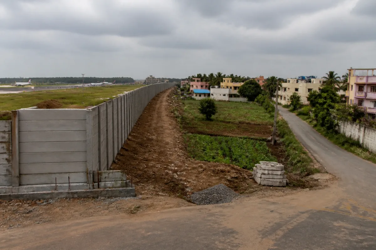
Coimbatore airport expansion has moved beyond a dispute over a perimeter wall. The ₹29-crore project now exposes a difficult urban question: how can a city secure land for major infrastructure without cutting off the homes, farms and neighbourhood roads that existed around it? Nearly 621 acres have been handed over to the Airports Authority of India (AAI), but disputes over acquisition, access and the design of connecting roads have stalled construction and triggered protests in Irugur, Chinniyampalayam and areas around SIHS Colony.
The immediate project is the construction of a 16.67-km precast compound wall around the newly acquired airport property. AAI floated a ₹29-crore tender in March 2025, with a scheduled construction period of 456 days. The wall is intended to secure the expanded airport land. But for residents whose plots and roads lie along the proposed boundary, the alignment has become the central issue.
The conflict is not simply about whether the airport should expand. It is about what happens to land and movement patterns once a large, restricted-use infrastructure site replaces a patchwork of private plots, agricultural land and local roads. A boundary that provides security for an airport can simultaneously become a physical barrier for the communities outside it. The dispute has therefore linked land acquisition, road planning, compensation and the sequencing of construction.
In Irugur, several landowners have approached the Madras high court seeking acquisition of their remaining parcels. They argue that the proposed wall would leave their properties without road access. One such landowner, T Padmapriya, said her partially acquired plot would be surrounded by three adjoining properties and become landlocked. She has sought either additional acquisition and a road or a modification that would leave a 15-foot strip outside the perimeter wall for partial access.
This illustrates a recurring problem in infrastructure acquisition: acquiring only the land required for the principal asset may not be enough to preserve the usability of the parcels left behind. A plot can remain legally with its owner while losing practical access to a public road. Once construction begins, restoring that access can require additional acquisition, a redesign or a separate road project. Each option adds administrative and financial complexity and can delay the main work.
The access problem is larger around the proposed approach road to the expanded terminal. The planned corridor is 1,917 metres long and 60 metres wide, connecting Avinashi Road to the new terminal through RG Pudur, Irugur and Chinniyampalayam. Residents and farmers have warned that fencing the corridor could sever the Irugur–Chinniyampalayam Road, the Venkittapuram–Irugur Road and SST Mill Road.
K Jayaprakash, a Chinniyampalayam resident and former councillor, said more than 500 families could be cut off if the Chinniyampalayam–Irugur Road is severed. Residents of Kurumbapalayam, Athappagoundenpudur and Irugur may be able to use a 5-km detour, but communities including RS Nagar, Old and New Krishna Gounder Nagar, Aishwarya Garden and Ramalingam Nagar could face more severe isolation, according to the report.
The numbers matter because road access is not an incidental benefit of an airport expansion. It determines how residents reach homes, farms, schools, workplaces, markets and emergency services. A detour that appears manageable on a planning drawing can impose a different burden on agricultural operations and neighbourhoods whose existing connections were built around short local routes. The report says the proposed fencing could affect more than 100 acres of agricultural land and residential plots.
Residents demanded 10-metre-wide service roads on both sides of the affected corridor. After a fresh survey in July, the district administration proposed a 40-metre main road with service roads, leading into a 10.5-metre-wide stretch for 1,750 metres along the new terminal campus. That proposal appeared to recognise that the airport approach could not be treated as a single fenced carriageway disconnected from the surrounding road network.
The dispute resurfaced in September when farmers alleged that AAI had withdrawn its assurance and rejected the 10.5-metre alignment in favour of a 3.75-metre service road. They argued that the narrower road would not be adequate for local traffic and sought a written commitment before construction resumed. The difference between the two proposed widths is not a minor technical detail. It represents a dispute over whether the corridor is being planned primarily as an airport access route or also as a functioning local connection.
The same issue appears near SIHS Colony, where residents have described stretches of the proposed path as barely five feet wide. G Vijayakumar said the width would be insufficient even for an autorickshaw or an ambulance. T Dharmaraj, councillor for Ward 55, has asked the state government to complete pending approach work on the Level Crossing 5 rail overbridge. The railway portion of the bridge is already complete, but the unresolved approach has added to concerns about connectivity.
Residents say that if the airport wall is built before these links are settled, SIHS Colony, Ganga Nagar, Kaveri Nagar, Bharathi Nagar, Amman Nagar, Moogambigai Nagar and Karunanidhi Nagar could be left without usable connectivity. This is the institutional challenge at the centre of the dispute: several authorities and projects are involved, but residents experience the outcome as one connected road system.
The airport expansion also has a longer history. Jayaprakash referred to the earlier designation of a 12,500-foot runway, saying that a collector had negotiated with AAI 15 years ago to reduce its length by 500 feet. His question—whether additional land could be acquired or the approach reduced by a further distance—shows how earlier compromises continue to shape current expectations. For affected residents, the precedent suggests that airport planning can be adjusted to accommodate local access. For the authorities, any change to a secured airport boundary or approach may involve operational and land requirements that are not resolved by a simple alignment revision.
The district administration has said it is handling the boundary-wall issues case by case. Coimbatore district collector Pavankumar G Giriyappanavar said landlocked cases had been identified and action initiated, with more than 70% of locations involving issues resolved. He added that some locations remain in litigation before the Madras high court and that the administration is coordinating with AAI.
That statement points to a two-track process. Some locations may be resolved through administrative intervention, while others will remain subject to court proceedings. But the wall, roads and terminal approach are physically connected projects. If work proceeds at locations where access questions remain unsettled, the administrative resolution of individual cases may not resolve the broader movement pattern. Conversely, delaying the entire boundary wall may affect the security and development schedule for the expanded airport property.
The supplied report does not establish the final approved road alignment, the current tender status after the disputes or the total compensation paid to affected owners. It also does not provide a final court ruling on the land acquisition petitions. Those gaps are important because the practical outcome will depend not only on assurances but on legally enforceable access, completed roads and a clear division of responsibility between AAI, the district administration, the state government and the railways.
Coimbatore’s airport expansion therefore demonstrates why infrastructure delivery cannot be measured only by land transferred or tenders floated. The 621 acres handed to AAI and the proposed 16.67-km wall are visible markers of project progress, but the less visible network of local roads and property access determines whether the expansion integrates with the city around it. The immediate test is whether the authorities can settle landlocked plots, preserve essential road links and provide a written, buildable access plan before the perimeter wall creates a barrier that is difficult to reverse.

