


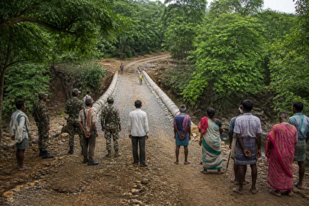
A 60-metre bridge built in Abujmarh by security personnel and tribal villagers is more than an improvised crossing over a deep ravine. It represents the first visible layer of a broader change in a region where insecurity, difficult terrain and the absence of basic infrastructure kept communities beyond the regular reach of the state for decades.
The bridge links Binagunda with the mainland and is expected to remain usable when monsoon waters previously cut the village off for about six months. According to the Times of India report, the structure will improve access for schoolchildren, pregnant women, senior citizens and patients requiring urgent medical attention. Its immediate value is therefore practical: it reduces the physical isolation that shaped everyday life in one of the most remote parts of Gadchiroli.
But the significance of the Abujmarh bridge lies in the way it was built and what that says about the changing institutional presence in the area. C-60 commandos, personnel from the Binagunda police assistance centre, the Central Reserve Police Force and the State Reserve Police Force worked with tribal residents to construct it. These agencies were previously associated primarily with security operations in a territory described in the report as a strategic Maoist stronghold. They are now also participating in a local infrastructure project.
That transition matters because connectivity in conflict-affected areas is not only a transport question. A bridge can determine whether a child reaches school, whether a pregnant woman can travel for care and whether an ill resident can reach a health facility before a condition becomes critical. In Binagunda, the ravine was not simply a geographical obstacle. It became a seasonal barrier that separated residents from services for a substantial part of the year.
The report describes Binagunda as a key point in the Red Corridor that remained effectively beyond development for four decades, despite its natural beauty and its description as the “Kashmir of Vidarbha”. That contrast captures the central urban and regional development problem in remote conflict zones: physical potential does not automatically produce public infrastructure. Roads, bridges, schools and healthcare access require administrative continuity, construction access, security and the ability to maintain assets after they are built.
## From security access to civic access
The Abujmarh project also illustrates the difference between reclaiming territory and making it liveable. The report links the acceleration of infrastructure expansion to the decline of the Maoist network and to the March 31 deadline set by Union home minister Amit Shah to eliminate Left-Wing Extremism. It says security operations have continued while civic infrastructure has begun to enter areas that were previously difficult or dangerous for public agencies to access.
The presence of a police post at Binagunda is described by Gadchiroli superintendent of police M Ramesh as a further strengthening of the state’s presence. That presence has two dimensions. The first is security: personnel remain vigilant about possible Maoist movement from neighbouring Chhattisgarh. The second is administrative and social: institutions that were once unable to work regularly in the area can now help address everyday mobility and service needs.
The bridge therefore cannot be understood only as a construction activity. It is also an indicator of institutional reach. A public authority is present not merely to conduct an operation, but to help create a crossing that residents use for education, healthcare and routine travel. The report quotes Ramesh as saying that the significance of the project extends beyond connectivity because personnel who were once exposed to ambushes and concealed explosives are now working alongside local residents.
That relationship is important in places where trust in institutions is shaped by daily contact. A bridge is a visible, shared asset. Unlike a security installation, it is used by residents for ordinary purposes and can make the state’s role tangible through improved access. The supplied report does not establish how local decision-making, ownership or future maintenance will be organised, but the community participation described in its account indicates that construction was not carried out solely as a security-led exercise.
## The infrastructure gap is measured in months
The most revealing figure in the report is not the bridge’s length but the period of isolation it addresses. Binagunda was reportedly marooned for six months during the monsoon because waters swelled across the ravine. This means that access to school, healthcare and the mainland was not an occasional inconvenience. It was a recurring seasonal condition that affected a large part of the year.
The 60-metre structure was built by bundling large cement pipes with cranes and using tractors and bulldozers to spread gravel and murrum around the crossing. The description points to a rapid, field-based construction response shaped by difficult terrain and operational constraints. It also shows why conventional public works delivery can be difficult in remote forest areas: materials, heavy equipment and workers must reach locations where logistics and security are themselves major challenges.
The article does not provide the bridge’s cost, engineering design, load-bearing capacity, ownership arrangements or maintenance schedule. Those details would be essential for assessing durability and whether the crossing can withstand repeated monsoon flows. The available evidence establishes its immediate social purpose and construction method, but not its long-term technical performance.
That limitation is significant. In remote areas, a new bridge can improve access only if the connecting paths remain usable, public services are available on the other side and the structure is maintained. The report identifies improved movement to schools and healthcare as expected benefits, but it does not state whether school capacity, medical staffing, ambulance availability or road conditions beyond the bridge have changed. Connectivity is a necessary condition for access, but it is not access by itself.
## A repeated model of community participation
The Abujmarh bridge is not presented as an isolated intervention. The report says a similar bridge was constructed at remote Nelgunda on September 13 with community participation. That suggests an emerging pattern in which security forces and residents are combining their capabilities to address basic infrastructure gaps in locations where civilian construction activity may previously have been constrained.
The model has clear operational logic. Security personnel can help create a safe working environment and bring access to equipment, while residents possess local knowledge of terrain, seasonal water movement and everyday travel routes. Community participation can also make a project more responsive to actual needs. However, the available report does not establish whether this approach is part of a formal government programme, a district-level plan or an individually organised response by security and local teams.
That institutional question deserves attention because the sustainability of such infrastructure depends on what follows construction. The report identifies the police assistance centre and multiple security agencies involved in the bridge, but it does not name the civil department responsible for future upkeep. Nor does it specify whether the bridge forms part of a wider road, school, healthcare or rural development plan.
The distinction matters for governance. Emergency or improvised construction can solve an urgent access problem, particularly in a conflict-affected area. Long-term public infrastructure, however, requires defined responsibility, regular inspection, predictable funding and integration with other services. Without those systems, a bridge may remain a valuable crossing but fail to produce the wider development effect that residents need.
## What the bridge confirms—and what remains unknown
The supplied evidence confirms a meaningful change in the relationship between security institutions, local communities and physical infrastructure in Abujmarh. A location described as a Maoist headquarters and a forbidden zone is now seeing joint work on an asset intended for everyday civilian use. The bridge reduces a seasonal barrier, strengthens links to the mainland and is expected to improve access to education and healthcare.
It also confirms that the end of armed control does not automatically resolve the infrastructure deficit. The region’s isolation was built over decades, and one crossing cannot by itself replace the network of roads, public facilities and administrative services that residents require. The bridge is best understood as an enabling piece of infrastructure and a marker of access, not as evidence that the wider development gap has been closed.
The next questions are consequently administrative as much as physical. Who will maintain the structure? What other links connect Binagunda to schools and health facilities? Will similar projects be extended to other isolated settlements? How will construction and public service delivery continue while security agencies remain alert to movement from neighbouring Chhattisgarh?
For now, the Abujmarh bridge offers a concrete measure of change: a ravine that once helped isolate Binagunda for half the year has become a site of joint construction. Its larger importance lies in whether that new crossing becomes the beginning of a durable civic network rather than a standalone symbol of recovered territory.

