


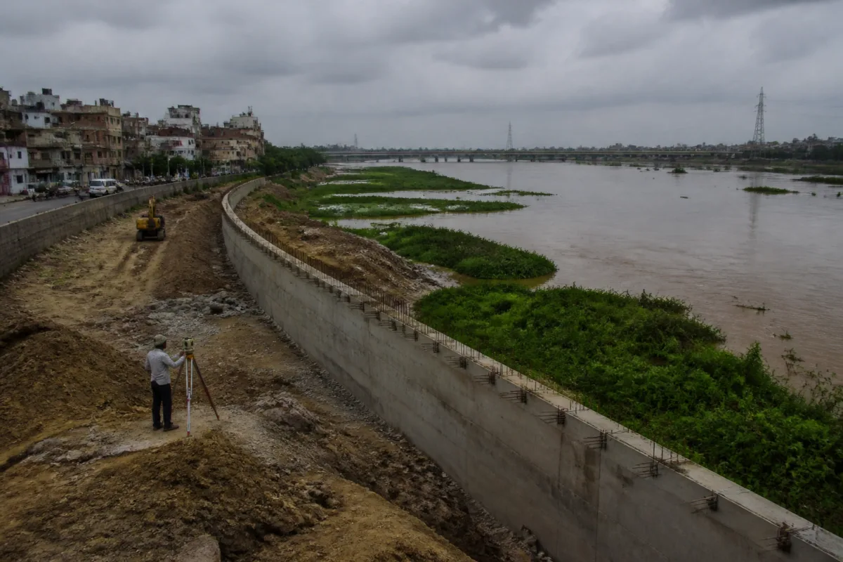
Delhi’s proposed Yamuna flood wall is presented as protection for low-lying neighbourhoods, but the project has exposed a larger question about how the capital manages a river whose flood behaviour appears to be changing. The 4.7-km reinforced concrete structure, estimated to cost Rs 99 crore, could shield selected stretches from inundation while also restricting floodwater movement and transferring risk to other areas, according to experts cited in the Times of India report.
The wall is part of a broader Rs 622-crore flood-control plan. It is expected to run from Magazine Road drain to the Old Railway Bridge and stand six to seven feet high. Its stated purpose is to protect vulnerable low-lying areas from flooding. Yet the central concern raised by the report is not whether Delhi needs flood protection. It is whether a fixed barrier along a constrained, largely monsoon-fed river can provide that protection without worsening the conditions that make flooding dangerous.
That distinction matters because flood infrastructure does not operate in isolation. A wall changes the relationship between the river, its floodplain, drains, roads, bridges and built-up areas. If water is prevented from spreading in one location, it still needs space to move through the wider river system. The experts cited in the report warn that a reinforced structure could alter the Yamuna’s natural flow, restrict floodwater movement and increase levels elsewhere. The concern is therefore about the distribution of risk, not only the protection of the stretch immediately behind the wall.
The available evidence points to a mismatch between upstream discharge and water levels recorded in Delhi. In September 2025, the Yamuna reached nearly 207.5 metres at the railway bridge when discharge at Hathnikund Barrage was reported at around 3.2 lakh cusecs. During the July 2023 floods, the river reached a record 208.66 metres at a reported discharge of around 3.5 lakh cusecs. The two figures do not establish a complete causal explanation, but they do show why experts are asking whether the river is carrying less water within Delhi than it did previously, or whether other changes are influencing flood levels.
The questions raised include the condition and capacity of the riverbed, encroachment on the floodplain, the effect of bridges and barrages, the role of embankments and riverside roads, and the cumulative impact of these interventions. The report does not provide a final technical finding on any of these factors. It does, however, identify them as issues that need to be examined before another major barrier is added to the system.
A senior government official quoted anonymously in the report questioned the logic of placing an additional barrier along an already constrained river. The official said that where buildings occupy the floodplain, further restricting floodwater could cause levels to rise. The official also warned that unequal pressure could lead to wall failure, with potentially catastrophic consequences. Because the official was not named, the observation should be read as an internal concern reported by the newspaper rather than as a formally documented government position.
Environmentalist Diwan Singh offered a separate critique of the project’s suitability to the Yamuna. He said that flood-control approaches used in Europe cannot automatically be applied to a largely monsoon-fed and restricted river. In his assessment, a wall could make the Yamuna function more like a canal, while reducing the floodplain’s ability to accommodate unpredictable flows. His argument shifts the focus from the engineering strength of the proposed structure to the ecological and hydraulic role of the floodplain itself.
The institutional context is important. Delhi’s flood-control plan includes not only the proposed wall but also Rs 260 crore for biomining projects intended to process silt removed from major drains. Better drainage may reduce local waterlogging, but the report’s experts distinguish between drainage management and river flood management. Drains can affect how quickly water leaves urban areas during rainfall. They cannot, by themselves, resolve questions about the Yamuna’s carrying capacity, floodplain connectivity or the behaviour of water entering Delhi from upstream.
The Central Water Commission’s 2025 study of the 2023 floods provides another layer to the discussion. The study recommended suitable flood protection at vulnerable locations, including Nili Chhatri, but did not specifically recommend the proposed 4.7-km reinforced concrete wall. Its modelling reportedly found that replacing certain existing lateral embankments with structures raised on piers could reduce water levels at some locations. That detail is significant because it indicates that the form of flood infrastructure can influence hydraulic outcomes. A solid wall and a structure that allows greater passage beneath it do not perform in the same way.
The report does not establish that the Central Water Commission study rejects the proposed wall, nor does it provide the full modelling assumptions or site-specific findings. It does show, however, that the proposed intervention is not the only structural option under discussion. The difference between containing water laterally and allowing flows to pass beneath infrastructure is a design question with direct consequences for flood levels, land use and public safety.
The proposed wall also sits within a wider pattern of planned intervention along the Yamuna. Similar concerns have been raised about Delhi’s proposed 22-km riverfront project. Experts cited in the report argue that river restoration and floodplain protection should take precedence over interventions that could further constrain the river. The relationship between these projects is not fully detailed in the supplied material, but their overlap raises an administrative question: whether flood control, riverfront development, drainage improvement and ecological restoration are being assessed as one connected river system or as separate packages of work.
That question is particularly relevant because the proposed flood-control plan combines different types of intervention. The wall addresses inundation along a defined stretch. Biomining addresses silt removed from drains. Existing bridges, barrages, embankments and riverside roads influence the river’s available space and movement. The riverfront project could alter the edge between the city and the floodplain. Each project may have a distinct agency, budget and approval process, but the floodwater does not recognise those administrative boundaries.
The figures in the report also show why the Yamuna cannot be assessed only through a single design height or one vulnerable location. A level of nearly 207.5 metres in September 2025 and a record 208.66 metres during the July 2023 floods indicate the scale of variation Delhi has recently experienced. The reported difference in upstream discharge between the two events is comparatively smaller than the difference in the river levels cited. These numbers are not sufficient to explain the relationship, but they make a case for examining local capacity, floodplain obstruction and infrastructure effects alongside rainfall and upstream releases.
The proposed intervention therefore raises a governance issue as much as an engineering issue. The decision to build a wall requires coordination between agencies responsible for flood control, drainage, river management, land use, infrastructure and environmental oversight. It also requires clarity on what evidence will be used to define the wall’s alignment, height and structural form. Without that information, the public can know the project’s cost and length but not how its performance will be judged or how risks outside the protected stretch will be managed.
Bhim Singh Rawat, associate coordinator of the South Asia Network on Dams, Rivers and People, said construction should be reconsidered until ongoing topographic and bathymetric surveys are completed. He also called for an independent investigation into the river’s carrying capacity and the cumulative impact of existing infrastructure. His position identifies two missing pieces in the current debate: updated physical information about the river channel and a system-wide assessment rather than a project-by-project review.
The evidence supplied in the report confirms that Delhi faces a genuine flood-management challenge and that vulnerable low-lying areas require protection. It does not establish that the proposed wall will cause flooding elsewhere, nor does it prove that the project is technically unsound. It establishes instead that important questions remain unresolved, particularly about the relationship between upstream discharge and Delhi’s water levels, the capacity of the river channel, the condition of the floodplain and the combined effect of existing and proposed infrastructure.
The immediate issue is consequently not whether Delhi should invest in flood control, but whether the Rs 99 crore wall is being evaluated within the full hydraulic and urban system of the Yamuna. The ongoing topographic and bathymetric surveys, any independent carrying-capacity assessment, and the government’s response to the concerns cited in the report will determine whether the project proceeds with a sufficiently broad evidence base.

