


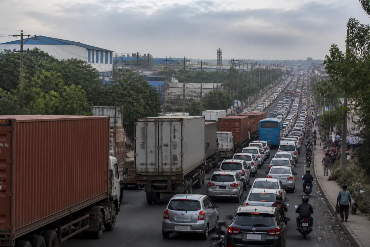
Chakan traffic congestion is no longer an occasional inconvenience on Pune’s industrial edge. A reported seven- to eight-kilometre queue on the Pune–Nashik route has brought into view a deeper mismatch: factories, warehouses, housing and heavy vehicles have expanded rapidly, while the road network serving them has largely retained its older capacity.
The immediate disruption was reported from Friday night, when vehicles travelling from Pune towards Nashik were forced into long queues. Workers, students, private commuters and ambulances were among those affected. The incident is significant not only because of the length of the queue, but because it shows how a transport bottleneck in one of Maharashtra’s major industrial corridors can become a daily access problem for an entire urbanising region.
Chakan sits within a wider employment and logistics system that links the Chakan industrial area, the Talegaon MIDC belt and routes towards Shikrapur and Nashik. The growth of manufacturing, freight movement and surrounding settlements has increased demand on two critical corridors: the Pune–Nashik highway and the Talegaon–Chakan–Shikrapur section of National Highway 548D. According to the figures reported by Lokmat, the road system has not expanded at the same pace as the traffic using it.
The reported traffic counts show the scale of the divergence. On the Talegaon–Chakan–Shikrapur corridor, daily traffic was estimated at about 12,000 to 15,000 passenger car units around 2016. Available 2026 figures cited in the report place the daily volume between 39,197 and 40,839 passenger car units. Passenger car units, or PCUs, convert different vehicle types into a common measure of road traffic and allow planners to compare the pressure created by cars, buses, trucks and other vehicles.
The Pune–Nashik route has seen a similar increase. The Bhawari–Moshi to Rajgurunagar section reportedly carried around 25,000 to 30,000 PCUs a day in a 2016 assessment. In 2026, traffic on some stretches between Nashik Phata and Chakan was reported at between 75,000 and 85,000 PCUs a day. These figures are attributed to the source report; the material supplied does not include the underlying traffic-count documents or details of how the measurements were conducted.
Even with that limitation, the direction of change is clear. The reported figures indicate a substantial increase in traffic over a decade, particularly on the approaches to Chakan. A road can become unreliable not only because of the number of vehicles, but also because of the mix of traffic using it. Chakan’s corridors carry trucks, containers, buses, private cars and two-wheelers at the same time. Industrial shift changes further concentrate demand during morning and evening peaks.
This is why the problem cannot be reduced to potholes or a single traffic-management failure. Road width, junction design, freight scheduling, local access, public transport operations and roadside land use all influence how quickly a corridor can absorb traffic. When these elements are managed separately, a road may be repaired without becoming more capable of handling the movement generated by the surrounding economy.
The reported queue also exposes the unequal effects of congestion. Industrial workers may lose hours travelling to and from employment. Students and schoolchildren face delays on routes that are also used by heavy vehicles. Private commuters can sometimes alter their departure times or routes, but workers tied to factory shifts have less flexibility. Ambulances face the most serious consequence: a network that cannot provide reliable passage during peak congestion can affect access to emergency care.
Chakan’s transport pressure is closely linked to its pattern of urban growth. Industrial estates generate freight and employment, but the housing, public transport, road hierarchy and civic infrastructure needed around them often develop later or in a fragmented manner. As settlements grow around employment centres, the same road may serve as a national highway, an industrial freight route, a local street and a public transport corridor. That overlapping role creates conflict between through-traffic and local movement.
The report also points to the limits of enforcement measures when they are not combined with network planning. Some encroachments in the Chakan area have reportedly been removed. However, widening has not kept pace with vehicle growth. Unauthorised rickshaw stands and the increasing number of rickshaws near Talegaon Chowk and Ambethan Chowk are identified as additional obstructions. Regulating stands and improving junction management may improve local flow, but these actions cannot by themselves resolve a capacity gap across an industrial corridor.
The institutional challenge is equally important. Chakan’s roads and traffic are not governed by a single urban function. National highways, district administration, industrial-area authorities, local bodies, traffic police, transport agencies and businesses may each control different parts of the problem. A pothole can be repaired by one agency, a junction managed by another and freight movement regulated by a third. Without a coordinated corridor plan, short-term works may address visible symptoms while leaving the underlying movement pattern unchanged.
The report says Deputy Chief Minister Eknath Shinde and Industries Minister Uday Samant visited the area in August 2026 after concerns were raised about congestion, poor infrastructure and the possibility of industries shifting elsewhere. The district administration set August 31 as a deadline for filling potholes, undertaking temporary repairs and removing traffic obstacles on highways and surrounding roads. The supplied material does not establish the full status of each action after the deadline, but it records that these measures have not resolved the wider congestion problem.
That distinction between maintenance and capacity is central. Filling potholes can reduce vehicle damage and improve safety. Removing encroachments can create space at specific points. Neither measure automatically provides additional lanes, alternative routes, freight-management systems or better-designed junctions. A permanent response would therefore need to address several layers of movement together: the main corridor, local access roads, industrial gates, intersections, public transport stops, rickshaw stands and heavy-vehicle operations.
The traffic numbers also raise a planning question about how industrial expansion is approved and serviced. If a corridor’s traffic rises from the reported 12,000–15,000 PCUs a day to nearly 40,000 PCUs, or from 25,000–30,000 to as much as 85,000 PCUs on some stretches, road capacity and junction performance cannot remain an afterthought. Industrial growth creates value and employment, but it also creates a predictable demand for freight access, worker mobility and emergency connectivity.
This does not mean that every congestion problem can be solved by widening roads. The supplied report does not provide a detailed assessment of land acquisition, public transport capacity, road-safety conditions or the feasibility of proposed alternatives. It does, however, show that the current network is carrying multiple types of demand beyond the level it was designed to handle. The resulting delays are being experienced not only by motorists but by the workforce and services that keep the industrial belt functioning.
The Chakan case therefore represents a broader urban governance problem: economic geography is changing faster than infrastructure institutions can coordinate. Factories and logistics facilities can expand within defined projects, while the public road network must absorb their combined impact across several jurisdictions. When planning is project-by-project, the cumulative traffic burden becomes visible only after queues, accidents, delayed deliveries and lost commuting time begin to affect the region.
The immediate evidence confirms a severe and recurring capacity problem, but it does not establish which permanent intervention will be implemented, by when or under which agency’s authority. The next meaningful test will be whether the administration moves beyond pothole repairs and obstruction removal towards a coordinated plan for widening, alternative routes, junction redesign, heavy-vehicle management and regulated local transport. Until then, Chakan’s industrial success will continue to be measured against a road system struggling to carry it.

