


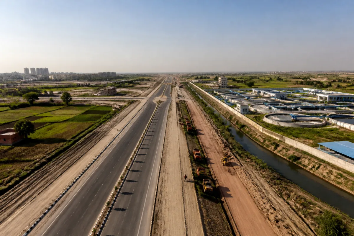
The proposed New Noida investment region is being presented as a planned urban extension with wide roads, canal-based water treatment and an infrastructure grid designed for future growth. But the project’s real significance lies beyond its promised amenities: it will test whether a large city can be assembled through land pooling, negotiated compensation and advance infrastructure planning before urbanisation takes hold.
The Noida Authority plans to develop the new city across about 200 square kilometres and has recommended adding four more villages to the proposed area. The addition would bring the planned city closer in size to present-day Noida, which has an area of about 203 square kilometres, according to the report by Live Hindustan. The larger footprint is intended to support an investment-oriented urban region rather than a small extension of the existing city.
The project comes as the institutional geography of Gautam Buddh Nagar has expanded over several decades. Noida was established on 17 April 1976 as the New Okhla Industrial Development Authority. Greater Noida Industrial Development Authority was created on 28 January 1991, followed by the Yamuna Expressway Industrial Development Authority on 24 April 2001. The proposed New Noida therefore represents another stage in a regional development model in which multiple authorities shape an interconnected urban and industrial corridor.
That history is important because the project is not being planned in an empty landscape. The proposed area includes 80 villages, while 32 villages have been identified for the first two phases. Land acquisition, compensation, village-level consent and restrictions on construction will determine how quickly the planned urban form can become reality. The project’s success will depend not only on its master plan but also on the administrative process through which land is assembled and converted into roads, utilities and development parcels.
### A road network designed around scale
The road plan is the clearest expression of the proposed city’s intended scale. A 130-metre-wide grid road is planned through the centre of New Noida, with additional roads measuring 105, 75, 70, 60 and 45 metres branching out on both sides. Noida Authority General Manager (Planning) Meena Bhargava said the layout has been designed around future requirements and the movement of heavy vehicles.
The authority’s stated objective is to ensure that a vehicle entering the central 130-metre road can reach either edge of the proposed city in about 30 minutes. That claim is an expression of the plan’s mobility ambition, but it also reveals the development model being pursued: a low-congestion, high-capacity city structured around a hierarchical road network and large development blocks.
The emphasis on road width reflects the industrial and investment focus of the project. Wide corridors can support freight movement, connect production areas and reserve space for future infrastructure. At the same time, the supplied report does not establish how public transport, walking, cycling or last-mile connectivity will be integrated into the road hierarchy. The available details focus on vehicle movement and heavy transport, leaving the broader mobility design of the future city unspecified.
That distinction matters because a large planned city is shaped not only by the width of its roads but also by what those roads connect. The report identifies the central grid and its branch roads, but it does not provide details of proposed employment clusters, residential densities, public transport routes, schools, hospitals or public spaces. These elements will determine whether the road system becomes the backbone of a functioning city or primarily a network for land development and freight access.
### Water security is being planned before construction
New Noida’s proposed water system is another major feature of the plan. The authority says no groundwater will be used for the city’s supply. Instead, water will be drawn from the Ganga canal system, with two additional canals running through the proposed area to be further developed. Six water treatment plants with a combined capacity of 310 million litres per day are planned along the canals.
The proposed plants include two facilities of 70 million litres per day each and one of 30 million litres per day along the Ganga canal, according to the report. The supplied account does not provide capacities for all six plants individually, but it places the treatment infrastructure at the edge of the canal network and links it directly to the planned urban expansion.
This approach places water sourcing at the centre of city-building rather than treating it as an afterthought. It also signals an attempt to avoid the groundwater dependence that has accompanied rapid construction in parts of the National Capital Region. However, the report does not establish the expected population, industrial demand, distribution network, sewage treatment capacity or reuse arrangements for the proposed city. Those details will be necessary to assess whether 310 MLD will be adequate across different phases of development.
The plan’s water promise therefore has two parts. The first is the source: surface water from the canal system rather than groundwater. The second is the institutional challenge of building treatment and distribution infrastructure in step with land development. Without information on demand projections and implementation milestones, the proposed capacity remains an important planning commitment rather than evidence of a completed water system.
### Land assembly will determine the project’s credibility
The first implementation test is land. Two general managers, 10 senior managers and two lekhpals have been deployed for land acquisition, according to the report. Of the 32 villages identified for the first two phases, 281 farmers have reportedly agreed to provide land to the authority. The authority has allocated an initial budget of Rs 100 crore.
Officials said land would be obtained through mutual consent and a land pooling model. For the first two phases, compensation has been fixed at Rs 5,725 per square metre, along with a developed residential plot equivalent to 6 per cent of the acquired land, following the policy used by the Greater Noida Authority. For the third and fourth phases, compensation is expected to follow the Yamuna authority’s model at Rs 4,558 per square metre, along with a developed residential plot equivalent to 7 per cent of the land.
These terms make the project’s land policy a central part of its urban policy. Compensation is not simply a financial transaction: the land pooling arrangement determines whether existing landowners can participate in the future urban economy or are separated from it through one-time payments. The developed plot component is intended to provide a continuing stake in the city, although the report does not provide details on eligibility, delivery schedules, location or the infrastructure that will accompany those plots.
The authority has also stated that compensation for land acquired in the first phase will be completed between December 2026 and March 2027. Officials further said that any construction within the boundaries of the 80 identified villages after 18 October 2024 would be considered illegal. This restriction is designed to prevent unauthorised development and speculative construction from complicating the planned layout.
The restriction also creates an immediate governance responsibility. Once construction is declared illegal, enforcement must be clear, consistent and accessible to affected residents and landowners. The supplied report does not detail the enforcement mechanism or the process for resolving disputes. Those institutional arrangements will be important because village land, existing homes and future urban zoning often overlap during the transition from rural settlement to planned city.
### The larger question is delivery, not scale
New Noida is being framed as an investment region that will combine industrial, commercial and residential growth with major road and water infrastructure. The project’s proposed area, road dimensions, treatment capacity and land-acquisition structure indicate a development model built around advance planning and large-scale infrastructure.
The evidence supplied so far confirms that the authority has identified an area, proposed a road hierarchy, planned canal-based water treatment, deployed acquisition staff, announced compensation rates and allocated an initial budget. It does not yet establish the final status of the master plan, the complete financing requirement, the sequencing of trunk infrastructure, the future population or the precise mix of land uses.
That gap between a city’s physical vision and its delivery framework is the central issue raised by the project. A 200-square-kilometre plan can reserve land and draw wide roads on paper, but its urban performance will depend on whether utilities, public facilities, transport links and residential development arrive together. The project will also have to manage the transition for villages whose land and construction rights are being reshaped by the plan.
New Noida is therefore more than an expansion announcement. It is an early test of regional planning in Gautam Buddh Nagar: whether multiple development authorities can extend the area’s industrial and real-estate growth without repeating the infrastructure gaps, groundwater dependence or fragmented development that large urban expansions can create. The next milestones are the inclusion of additional villages, landowner agreements, compensation payments beginning in December 2026, and the translation of the proposed road and water systems into approved and funded infrastructure works.

