


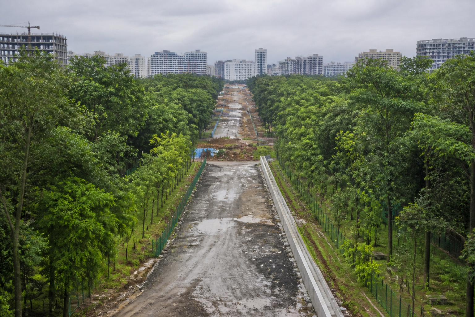
Bengaluru’s Panathur CDP Road is moving ahead through a 150-acre urban forest in Gunjur, ending years of uncertainty over the road’s alignment but creating a permanent break in one of east Bengaluru’s established green spaces. The project brings into focus a recurring planning conflict: infrastructure corridors are often finalised over time, while the ecological and public value of land becomes visible only after the alignment is difficult to change.
According to officials cited by the Times of India, the 150-ft road will pass through the forest, while a tree park will continue on either side of the corridor. The first phase of the Panathur Tree Park, spread across nearly 40 acres, is scheduled to open to the public on Wednesday. More than 100 acres beyond the road alignment will remain under the Forest Department and are expected to be fenced and secured.
The immediate arrangement is therefore not a complete loss of the forest. It is a division of the forest into two sections. That distinction matters because the decision affects not only the number of trees removed or the area diverted, but also the continuity of the green space. The road corridor is expected to use a strip approximately 25 metres wide and 400 to 500 metres long. Forest officials cited in the report said the land diversion would physically bifurcate a green area that took roughly four to five decades to develop.
The history of the site helps explain why the conflict emerged so late. Forest officials said the land was notified as forest land in 1987, after which afforestation activities were undertaken. Over the following decades, thousands of trees were planted and the site developed into a dense urban forest. The land was not simply an undeveloped parcel awaiting construction; it became a functioning green asset within a rapidly urbanising part of Bengaluru.
At the same time, the Panathur CDP Road has been part of the area’s infrastructure plans for years. Forest officials said the road was proposed around 2008. They also said that the Forest Department was not approached at that stage even though the proposed alignment passed through forest land. The road was subsequently constructed from both ends, but remained incomplete at the forest stretch and at a few other pending sections.
This sequence reveals the administrative problem at the centre of the dispute. A road can exist as a planning proposal for years without the land-related questions being resolved. When construction begins from adjoining areas, the alignment acquires physical and institutional momentum. By the time the forest authority is formally approached, alternatives may appear more expensive or disruptive, even if they would have protected the continuity of the forest.
The issue became more prominent after the Forest Department began developing the site as a tree park in 2020 under the Centre’s Nagar Van Yojana. Officials said public investment was made to improve the area and create an accessible green space. The tree park project changed the status of the land in practical terms: a forest that had grown over decades was also being shaped into a public urban amenity.
That created two parallel public claims on the same land. The road is intended to improve movement between Panathur, Gunjur and surrounding areas. The tree park is intended to preserve and open up a significant green pocket. Residents therefore face a choice that was not created by a single day’s announcement. The choice was built into the planning process through the coexistence of an old road proposal and a later public-green-space project.
The road’s expected mobility value is clear from its scale and location. A 150-ft CDP road can provide a wider east Bengaluru connection and may ease movement in an area where development has increased pressure on local roads. The report does not provide traffic volumes, travel-time estimates or a completion schedule, so the precise operational gains cannot be established from the available information. What is established is that the project has remained incomplete at the forest stretch while other portions have progressed.
The environmental cost is also more specific than a simple calculation of diverted acreage. The proposed corridor would occupy only a portion of the 150-acre forest, but its width and length would create a continuous physical barrier across the green space. Forest officials said alternative approaches, including an elevated corridor or an underpass, were discussed. Their stated argument was that current technology could have allowed the road to pass without disturbing the forest’s continuity, although such alternatives might have cost more.
The source material does not establish whether a formal comparative assessment of these options was completed, nor does it provide cost estimates, engineering reports or an environmental impact assessment. That missing information is important because the decision involves more than a binary choice between connectivity and conservation. It involves comparing different infrastructure designs, their costs, their construction timelines and their long-term effects on the forest.
The institutional responsibilities are spread across several authorities. The Forest Department controls the notified forest land and is responsible for protecting the remaining area. Bengaluru East City Corporation is constructing the 150-ft CDP Road. The corporation has received government approval to compensate land in Belthangady for making way for the road at Gunjur. The report does not specify the full approval chain, the value of the compensation or how the compensatory land will be managed.
That arrangement illustrates a broader governance challenge. Land compensation can address the area diverted from one site, but it does not automatically reproduce the ecological continuity of the original forest. In this case, the immediate protection measure is physical security for the remaining land. Officials said the 100-acre stretch beyond the road corridor would be fenced and compounded to prevent future encroachments or additional diversion.
Fencing may reduce the risk of further land loss, but it also shows how the public value of the forest is being managed after the alignment decision has effectively been made. The remaining land is to be protected because officials fear additional pressure. The need for that protection is itself evidence that the road is not being treated as an isolated intervention, but as a possible opening for future encroachment or piecemeal conversion.
The Panathur case also exposes a difference between preserving green cover by area and preserving it as a connected landscape. More than 100 acres may remain under the Forest Department, and the tree park will make part of the site accessible to residents. Yet the forest’s function as a continuous space will change once a road cuts through it. The supplied report does not quantify the effect on wildlife, groundwater, temperature or air quality, so those impacts cannot be assumed. It does, however, establish that the physical continuity of the forest will be lost.
This is particularly relevant in a city where infrastructure expansion and urban growth often advance through separate institutional decisions. A road authority may assess connectivity, while a forest authority assesses land protection and a municipal body develops public access. Each decision can be defensible within its own mandate. The conflict appears when the decisions converge on the same parcel and no early mechanism has forced the alternatives to be evaluated together.
The timeline in Panathur suggests that earlier coordination could have changed the terms of the decision. The road was proposed around 2008, while tree-park development began in 2020. Forest officials say they were approached for land only after the park work had started. The available account does not establish which authority was responsible for initiating coordination or whether the road alignment had been formally reviewed after the land was notified as forest. It does show that the issue remained unresolved for years while the road was built from both ends.
For residents, the outcome is a compromise with two visible results. The long-pending road is expected to improve connectivity, while the opening of the tree park will provide public access to a green space that had grown largely outside everyday public use. But the compromise also transfers a long-term cost to the urban landscape: a forest that developed over four to five decades will no longer function as one uninterrupted area.
The key question is therefore not whether Bengaluru needs roads or forests. It is whether the city’s planning system can identify and resolve conflicts between them before construction becomes irreversible. Panathur shows what happens when an old transport alignment, a notified forest and a later public-park programme occupy the same planning field without a publicly documented resolution of alternatives.
The available evidence confirms that the current plan will use a 25-metre-wide, 400-to-500-metre-long strip through the forest, while the remaining area is to be fenced and protected. It does not establish the comparative cost of an elevated road or underpass, the project’s final completion date, or the full environmental assessment behind the chosen alignment. Those details will determine whether the Panathur decision remains a one-time compromise or becomes a precedent for treating fragmented green infrastructure as an acceptable cost of urban connectivity.
