


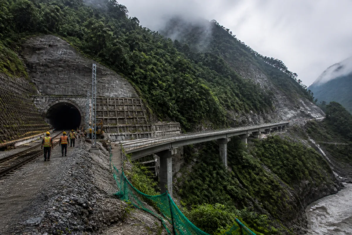
The Sevoke–Rangpo railway project is expected to give Sikkim its first direct railway connection to India’s national network by December 2027. But the line’s long construction history and unusual engineering profile show that the state’s railway gap is not simply the result of delayed government investment. It reflects the difficulty of building transport infrastructure in a young, seismically challenging mountain system where tunnels, slopes, rainfall, forests and land acquisition all shape the timetable.
Sikkim is currently the only Indian state without an operational railway station. Travellers generally reach New Jalpaiguri in West Bengal and continue by road towards Gangtok and other destinations. Others use Pakyong Airport when flights are available, while NH-10 remains the principal road connection from the Siliguri region. This dependence on a limited number of transport links makes the state particularly vulnerable when landslides, monsoon rainfall, congestion or adverse weather disrupt movement.
The railway project was sanctioned in 2008-09, but substantial construction did not begin until 2018. The delay reflected several overlapping requirements rather than one isolated bottleneck. Environmental and forest clearances, land acquisition, difficult terrain and the complexity of constructing in ecologically sensitive areas all affected progress. Work was also disrupted between 2020 and 2022 by the Covid-19 pandemic, while earlier completion deadlines were revised as the physical and administrative challenges became clearer.
The Sevoke–Rangpo line is approximately 44.96 km long. About 41.55 km of the alignment lies in West Bengal and around 3.41 km in Sikkim. Its short length is deceptive: approximately 38.6 km, or about 86% of the route, is planned to run through tunnels. The project includes 14 tunnels, major and minor bridges, and five stations at Sevoke, Riyang, Teesta Bazar, Melli and Rangpo. Teesta Bazar is designed as an underground station.
This design is a direct response to the landscape. A conventional surface railway through steep Himalayan slopes would require extensive cutting and could create greater disturbance across valleys and forested areas. The underground alignment can reduce the amount of surface infrastructure, but it shifts the challenge below ground, where engineers must manage changing rock conditions, slope stability and the behaviour of the surrounding terrain.
The tunnelling work uses the New Austrian Tunnelling Method, or NATM. The method allows support measures to be adapted to the ground conditions encountered during excavation. That flexibility is important in a region where the geology can vary sharply over short distances. The longest tunnel on the route is about 5.3 km, and the line also requires bridges to cross valleys and negotiate uneven terrain.
The project’s setting makes construction risks inseparable from the region’s wider transport risks. Heavy rainfall can trigger landslides and disrupt both construction sites and existing roads. NH-10, the critical route linking the Siliguri area with Sikkim, has repeatedly faced road blockages and landslides. When the highway is closed or traffic slows, passenger journeys and the movement of essential supplies are affected.
A landslide near Tunnel No. 7 at Rabijhora in August 2025 illustrated the operational difficulty. Heavy rainfall caused a slope failure about 30 metres from the tunnel and damaged part of the protective structure at the tunnel approach. Northeast Frontier Railway said the tunnel itself was not in danger. No casualties, injuries, machinery loss or asset damage were reported. Workers and equipment had been moved away as a precaution, and debris removal and protective work began after the incident.
The incident does not establish that railway construction caused the landslide. It does, however, demonstrate the kind of site-specific hazard that infrastructure agencies must manage in the Himalayan environment. Rainfall, unstable slopes and difficult ground conditions can affect construction safety even when the main tunnel structure remains secure. They also help explain why progress on this line cannot be assessed only by comparing its length with that of a railway project in relatively level terrain.
As of September 2026, overall work was reported to be approximately 80% complete, with the Teesta Bazar underground station nearing completion. The latest target is December 2027. That target is the immediate milestone for Sikkim’s railway connectivity, but it should not be confused with the completion of a railway network across the state. The Sevoke–Rangpo line would connect Rangpo to the national network; it would not take trains directly to Gangtok.
A proposed Rangpo–Gangtok railway line of approximately 34 km is being assessed as an extension under the multimodal planning process associated with the PM Gati Shakti National Master Plan. A separate final location survey has also been approved for a proposed route linking Melli to Dentam through Jorethang and Legship. That route is around 75 km long. A survey approval is an early planning step and does not amount to final approval for construction.
This distinction is important because transport discussions often combine operational projects, proposed extensions and long-term strategic visions. The immediate Sevoke–Rangpo project has a defined alignment, stations, construction activity and completion target. The proposed extensions remain at different stages of evaluation or survey. Their eventual progress would depend on further planning, approvals, clearances, funding and construction decisions that are not established in the supplied material.
The first line’s significance is therefore practical as well as symbolic. It could provide an additional passenger and freight route for a state that currently relies heavily on roads. Travellers would still need road transport to reach Gangtok and other destinations beyond Rangpo, but the railway could change the first part of the journey from the plains. It could also offer another channel for moving supplies when road conditions deteriorate, although the extent of that benefit would depend on the eventual operating pattern and onward road connections.
The project also has a strategic dimension because Sikkim shares a border with China. Improved railway access could strengthen transport links to a strategically important region and support the movement of goods and supplies. The specific operational or defence benefits would depend on how the network is used after it becomes functional; the supplied material does not establish those future outcomes.
The wider lesson is that connectivity in mountain states cannot be measured only by kilometres of track or the number of stations. It also depends on resilience across the entire transport chain. A railway may reduce dependence on a vulnerable highway, but passengers and freight can still face delays on roads connecting stations to towns, markets and border areas. The railway’s effectiveness will therefore be linked to the reliability of NH-10, local roads, station access and future extensions.
Sikkim’s railway project brings together several difficult questions in Indian infrastructure planning: how to connect remote regions without ignoring ecological constraints, how to build safely in unstable terrain, and how to balance strategic access with local mobility and environmental risk. The evidence confirms that the Sevoke–Rangpo line is substantially advanced and targeted for completion in December 2027. What remains to be monitored is whether that target holds, how the completed line operates during difficult weather, and whether proposed extensions beyond Rangpo move from surveys and assessment to approved construction.

