


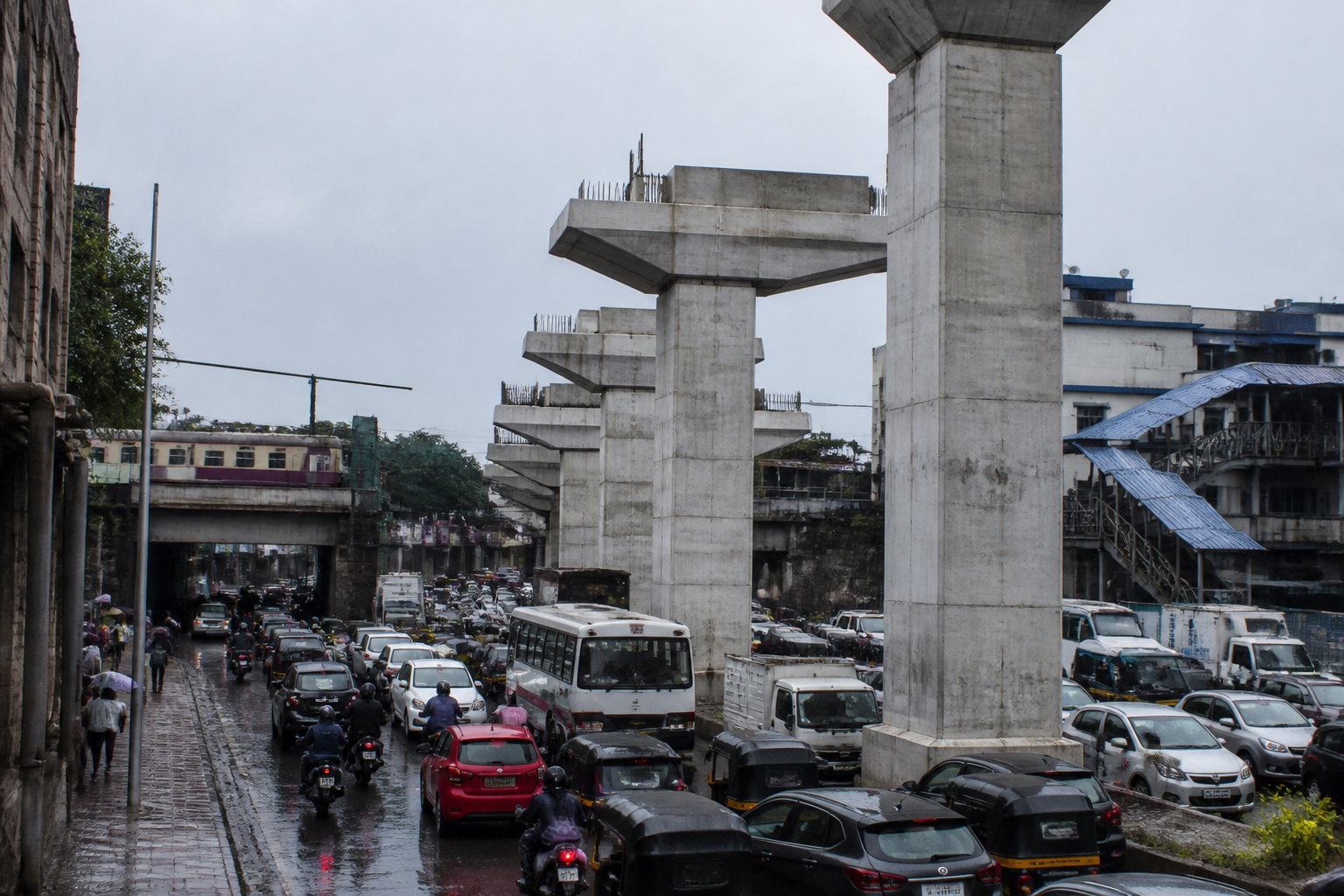
Pune Metro pillars along the Shivajinagar-Khadki corridor are becoming a test of whether the city can build mass transit without weakening the streets around it. A Civic Mirror inspection reported narrow traffic lanes, difficult turns, pedestrian conflicts and congestion near Khadki, Bopodi and Shivajinagar, where metro columns share limited road space with buses, cars, autorickshaws, two-wheelers and pedestrians.
The report does not establish that the metro system itself is the sole cause of congestion. It does, however, document a recurring design problem: infrastructure intended to improve public transport has been inserted into already constrained corridors without a consistently protected movement plan for every user. At several locations, vehicles must pass through narrow gaps between columns, road edges and other infrastructure. The result is not simply slower traffic. It is a street where different modes compete for the same small amount of space and where minor disruptions can affect the wider traffic flow.
That distinction matters. A metro viaduct is usually evaluated as a transport structure: its alignment, stations, columns and engineering requirements are examined to determine whether trains can operate safely. But the road beneath and around it is a living public space. It must also accommodate turning movements, pedestrian crossings, bus operations, informal stopping, drainage, access to adjoining properties and the transition between different transport modes. The Civic Mirror report suggests that the corridor-level consequences of these requirements have not been handled consistently.
The pressure is particularly visible near transport interchanges. Khadki has a railway station, bus services and a metro station in close proximity, making it an important transfer area. This concentration should allow passengers to shift easily between modes. Instead, the report describes locations where the road suddenly narrows near the metro and railway facilities, bringing pedestrians and vehicles into the same constrained space. A transport interchange can therefore become a bottleneck if the connection between modes is not designed as carefully as the individual stations.
The problem is not limited to vehicles moving through the corridor. Pedestrians are also affected when columns sit near crossings, footpaths or junctions. Transport expert Pranjali Deshpande told Civic Mirror that a pedestrian crossing should not lead directly towards a metro column. Where an obstruction interrupts the natural crossing line, pedestrians may be forced to change direction or move closer to live traffic. Her point identifies a basic design responsibility: people using a street should not be expected to independently negotiate obstacles created by infrastructure.
The same principle applies to road capacity. Deshpande argued that planners should examine the narrowest part of the entire corridor rather than assess each section in isolation. A road may expand from two lanes to three and then return to two lanes a short distance later. Such changes create a physical discontinuity in the traffic system. The additional lane does not necessarily improve movement if vehicles must merge again almost immediately. In a corridor carrying buses, autorickshaws, cars and two-wheelers, the merge itself becomes a conflict point.
The report’s description of two-wheelers moving close to metro columns and larger vehicles illustrates how these conflicts develop. Riders may use the narrow spaces between columns and moving traffic because those spaces appear available. But they must eventually re-enter the main traffic stream. That creates a second conflict at the point of merging. Deshpande said each column should have a defined buffer zone and that the space between successive columns should be managed consistently rather than left as an irregular residual lane.
This is a street-design issue as much as a traffic-management issue. When the usable width changes from one point to another, drivers respond through informal behaviour: vehicles stop along the edge, two-wheelers filter through gaps, autorickshaws occupy parts of the carriageway and larger vehicles attempt turns with limited clearance. These actions may be individually understandable, but together they make movement less predictable. At a busy junction or station approach, unpredictability increases the possibility of sudden braking, side-swiping and pedestrian conflict.
The Khadki railway underpass is an especially important example because the underpass was already a narrow corridor before the metro columns added another physical constraint, according to the report. A traffic police official suggested that one-way operation could be considered to reduce conflicts between vehicles travelling in opposite directions. Pune’s Additional Commissioner of Police for the western and traffic divisions, Manoj Patil, said a proposal was being prepared to make the Khadki railway underpass and the Poultry underpass one-way.
That proposal is significant because it shows the administrative response currently available when a corridor becomes difficult to operate: change traffic rules after the infrastructure is in place. A one-way arrangement may reduce opposing movements in a narrow section, but the report makes clear that it would require a detailed traffic study. It would also shift the pressure to connecting roads and junctions. The supplied material does not establish whether the proposal has been approved, when it would be implemented or what its effect would be on surrounding streets.
The larger institutional question is who is responsible for the complete street created by a major transport project. Metro construction involves specialised engineering, but the corridor also belongs to the municipal road agency, the traffic police, the railway system, bus operators and district administration. The commuter experience depends on all of them functioning as one network. If each agency plans only the part under its control, the gaps appear at precisely the places where passengers and vehicles change direction.
Deshpande told Civic Mirror that metro alignments should be developed with road and street-design experts, not only with attention to the viaduct. She distinguished between road engineering, which considers elements such as curves, turning radii, medians and gradients, and street design, which considers the full space between property boundaries. That distinction is central to Pune’s present problem. A column can be technically positioned within an approved alignment and still produce a poor street if the remaining space cannot support safe movement.
The issue also affects future expansion. Deshpande specifically called for street design to be prepared alongside the proposed Pimpri-Nigdi and Vanaz-Chandni Chowk metro extensions. She said columns should be kept away from junctions and pedestrian crossings, while connections with other transport modes should be planned in advance. The recommendation is not simply to reserve more road width. It is to decide early how every part of the corridor will work before construction fixes the most difficult elements in place.
This is where the metro-pillar debate intersects with multimodal integration. Khadki’s railway, bus and metro facilities create the potential for passengers to transfer without using private vehicles. But that potential depends on safe pedestrian routes, clear information, convenient interchange arrangements and coordinated fare systems, according to Deshpande. The Civic Mirror report does not provide details on whether such integration is currently being implemented in Khadki. It does show that physical proximity between stations is not enough to create a functioning interchange.
The report also records the daily cost experienced by commuters. Mukesh Chaudhary, who travels near Khadki metro station, said weekday journeys take an additional 30 to 45 minutes because of the railway underpass, flowing rainwater and the metro columns. Other commuters cited difficulty for four-wheelers and called for Pune Municipal Corporation, MahaMetro and the district administration to prepare a joint plan. These accounts are individual testimonies, not a measured corridor-wide travel-time study, but they provide a ground-level indication of how design decisions are experienced during peak periods.
The reference to rainwater adds another layer to the problem. A narrow underpass with drainage difficulties has less tolerance for additional obstructions and slower traffic. When vehicles, pedestrians and water movement compete in the same constrained area, the corridor’s weakness becomes more visible during adverse conditions. The supplied report does not quantify flooding or drainage performance, but it identifies water accumulation as part of one commuter’s explanation for slower journeys.
The report also raises a question about how public authorities define an obstruction. A Maharashtra Vruksha Samvardhini activist contrasted the treatment of trees with the treatment of metro columns, arguing that trees are often considered obstacles to road or development works while columns placed close to the centre of a road are not treated in the same way. That is an attributed criticism rather than an independently established policy finding. Still, it points to a wider planning concern: environmental and transport decisions can appear inconsistent when different types of fixed objects are assessed through separate administrative processes.
What the evidence confirms is narrower but important. Pune’s metro corridors require evaluation as complete streets, not only as rail structures. The Shivajinagar-Khadki stretch brings together constrained carriageways, major transport nodes, pedestrian crossings, underpasses and mixed traffic. In such settings, the position of each column affects lane continuity, turning movements, pedestrian access and the ability to manage emergencies or temporary disruption.
What remains unclear from the supplied material is the extent of the problem across the full corridor, the number of crashes attributable to the columns, the exact engineering standards used during construction and the status of proposed traffic changes. The report refers to frequent accidents in its translated presentation, but it does not provide an official crash dataset. Those questions require traffic counts, road-safety audits, pedestrian movement studies and transparent design documents.
The next test for Pune is therefore not only whether the police can reduce congestion through one-way arrangements. It is whether MahaMetro, the municipal corporation, the traffic police, railway authorities and the district administration can establish a shared corridor plan. The proposed changes at the Khadki and Poultry underpasses, along with the planning of future metro extensions, will show whether the city treats street design as an essential part of public transport delivery or as a problem to be managed only after the pillars are already standing.
