


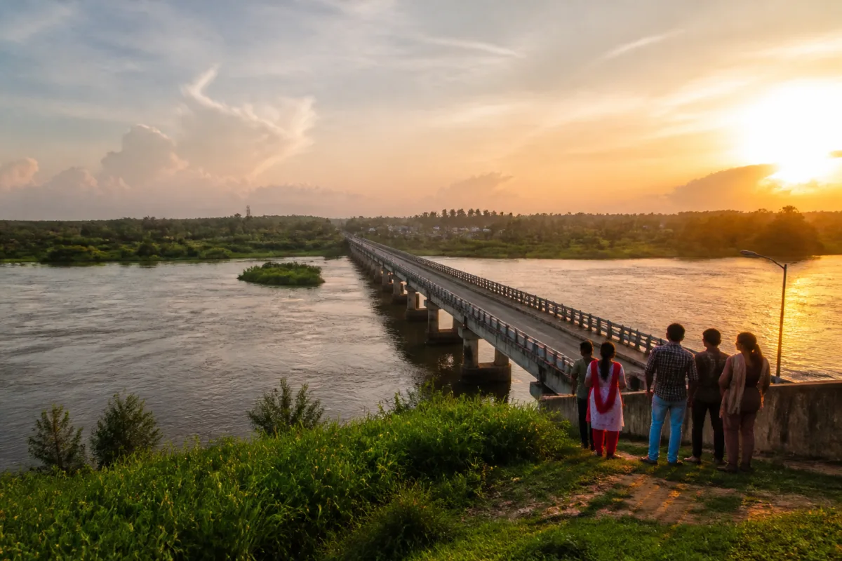
Puthenvelikkara tourism is being shaped not by a single attraction, but by the interaction of a bridge, a flood-prone river landscape, recovering farmland and improved access. A village once associated in popular memory with severe drinking-water scarcity is now being presented as an emerging destination in Ernakulam district, with evening visitors gathering at the Stationkadavu Bridge, travellers viewing Malavanappara and tourists arriving to see the water lily fields at Thazhanjira.
The transformation, as described in a report by Malayala Manorama, is significant because it links tourism growth to infrastructure that was not originally built as a tourism project. The Stationkadavu Bridge, also referred to as the Puthenvelikkara Bridge, reduced the difficulty of reaching the village from North Paravur and nearby parts of Ernakulam. Its more consequential test came during the 2018 floods, when the bridge became an important route for residents and rescue operations after surrounding roads were submerged or closed.
That history gives the destination a different urban and regional significance. Puthenvelikkara is not a conventional city-centre attraction. It lies near the meeting point of the Periyar and Chalakudy rivers, close to the Paliam area, and is characterised by river edges, paddy fields, slopes and village roads. Its tourism profile is therefore inseparable from the condition of its transport links and from the risks associated with living at the confluence of two rivers.
The report places the current identity of the village against its cinematic past. The 1975 Malayalam film Utsavam, directed by I.V. Sasi, used a village facing a severe drinking-water problem as its setting. The report identifies that location as Puthenvelikkara and says the area’s drinking-water difficulties have since been resolved. The contrast is central to the story: the same place once represented through a basic service deficit is now being recognised for its landscape and connectivity.
The supplied report does not provide project costs, visitor counts, detailed water-supply records or an official tourism plan. It does, however, describe a clear sequence of change. Puthenvelikkara was once difficult to access from North Paravur because travellers had to cross the Manjali Bridge and proceed through Kanakkan Kadavu and Elanthikkara. The opening of the Stationkadavu Bridge in 2018 shortened the journey and reduced travel difficulties, bringing the village closer to established urban and suburban circuits.
This is the first important lesson in the area’s tourism evolution: access can change the value of a landscape without changing the landscape itself. The Periyar, the paddy fields and the riverine rock formation at Malavanappara existed before the bridge. What changed was the ease with which residents and visitors could reach them. Better connectivity made the village more visible and converted places known primarily to local communities into destinations for visitors from Kochi and Paravur.
The bridge’s role during the 2018 floods adds a second layer. Puthenvelikkara was among the areas in Ernakulam district facing serious flood threats because of its location near the Periyar and Chalakudy rivers, according to the report. When floodwater entered homes and road access was cut, the recently opened bridge became a route to safer locations. It also helped move people rescued by boats and other means towards relief camps.
That experience shows why transport infrastructure in riverine settlements cannot be evaluated only through routine travel-time calculations. A bridge can support daily mobility in normal conditions and become a critical evacuation link during a disaster. Its value is therefore operational as well as economic. In Puthenvelikkara, the same structure that improved access for visitors also became part of the community’s emergency geography.
The report now describes the Stationkadavu Bridge as an evening gathering point. People arrive to experience the cooler air from the Periyar, the village setting and sunset views. Visitors from Kochi and Paravur use the bridge area as a place to spend time away from urban congestion. This shift from transport infrastructure to public gathering space is common in places where bridges offer elevated views, open skies and contact with water, but it also raises questions about how such spaces are managed.
The supplied material does not establish whether the bridge has designated pedestrian areas, lighting standards, parking arrangements, waste facilities, safety barriers or visitor-management systems. These details matter because rising popularity can place pressure on infrastructure that was designed primarily for movement rather than recreation. A bridge that works as a transport link may not automatically function safely as a public viewing deck or social space.
Malavanappara provides another layer to the emerging destination. The large rock formation rises from the Periyar near the Malavana Shiva temple and is described as visible in both summer and the monsoon. Its location in the river, combined with the temple setting, gives Puthenvelikkara a landscape that is simultaneously natural, religious and local in character. Visitors can view the rock and the surrounding water either by boat or from nearby areas, according to the report.
The presence of a religious site beside a natural formation is not unusual in Kerala, where settlement, worship and water landscapes often overlap. But it means that any growth in visitation affects more than scenery. It can influence access to the temple, boat movement, riverbank use and the relationship between local religious activity and leisure travel. The report presents this combination as a distinctive spiritual and tourism experience, while leaving the institutional arrangements around it unspecified.
Thazhanjira paddy fields represent a third form of attraction. The report says the area has gained attention through social-media reels and short videos showing blooming water lilies surrounded by green farmland. The fields are described as particularly attractive in the morning, while the wider setting is becoming an evening destination similar in atmosphere to other popular village-edge locations such as Kadamakkudy, Chathanad and Kumbalangi.
The contrast between morning flower viewing and evening gathering shows how digital visibility can expand the use of rural landscapes across the day. It also shows the importance of agricultural land to the region’s visitor economy. The paddy fields are not a constructed tourism product; their appeal depends on cultivation, seasonal water conditions and the continued presence of open land. If those underlying conditions change, the attraction itself changes.
The report does not include visitor data or evidence of commercial development around Thazhanjira. It therefore cannot establish the scale or economic impact of the trend. What it does document is a change in perception: a location previously outside the main tourism circuit is now being circulated as a place for photography, short visits and local leisure.
Puthenvelikkara’s experience also illustrates the limits of describing tourism development only through destination branding. The village’s emergence is tied to public infrastructure, flood memory, local geography and improvements in a basic service. The bridge did not merely bring tourists in; it changed the community’s relationship with surrounding towns and proved useful during a crisis. The river and fields did not suddenly become attractive; improved access and digital circulation altered who could see them and how they were used.
The governance question is therefore broader than whether Puthenvelikkara should be promoted as a destination. It concerns coordination between transport authorities, local government, disaster-management agencies, temple or community institutions and residents. The supplied report does not identify the responsible agencies or announce a formal tourism-management framework. It also does not indicate whether any carrying-capacity assessment, safety audit or conservation plan has been prepared.
Those gaps are important because the attractions described are dispersed across a living settlement rather than concentrated inside a managed tourist facility. Visitors move through bridges, roads, fields, river edges and religious spaces. This pattern can support local economies, but it can also create unmanaged parking, litter, crowding, unsafe viewing points and disruption to farming or community activity if growth accelerates.
The available evidence confirms a physical and perceptual transition, but not yet a quantified tourism boom. Puthenvelikkara has better access than it did before the Stationkadavu Bridge, the bridge played a reported role during the 2018 floods, and local landscape features are attracting residents and visitors. The scale of visitation, the revenue generated and the infrastructure burden remain unestablished in the supplied material.
That distinction matters. For now, Puthenvelikkara is best understood as an example of how resilient infrastructure and ordinary rural landscapes can combine to produce a new destination. Its future significance will depend on whether the village’s roads, river edges, agricultural land and public spaces can accommodate growing attention without losing the qualities that made them attractive in the first place.

