


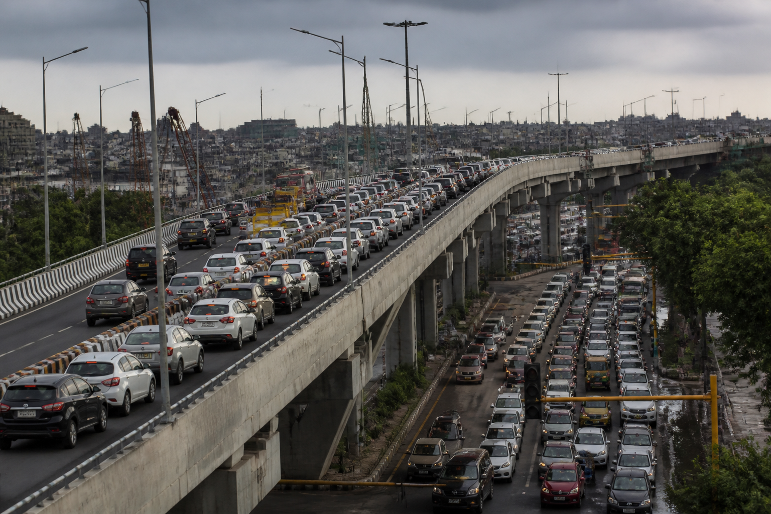
The traffic problems on Delhi’s newly opened Barapullah Phase III corridor have exposed a familiar weakness in urban infrastructure: a road can be completed and opened, yet still fail to deliver a smooth journey if its junctions, adjoining roads, construction interfaces and traffic information systems do not work as one network. The Public Works Department is now reviewing traffic flow on the elevated stretch after repeated bottlenecks were reported within days of its opening.
The corridor was inaugurated on September 29 and connects Mayur Vihar Phase-I with Sarai Kale Khan along the Ring Road. It was presented as a key link between east and south Delhi, with the wider Barapullah network extending towards the AIIMS roundabout. Its intended role was to provide a smoother alternative for motorists and reduce pressure on routes around the DND and Akshardham. Instead, regular traffic build-up has prompted the PWD to discuss possible changes with the Delhi Traffic Police and the National Highways Authority of India.
No structural modification has been finalised. An official cited in the report said the agencies met to examine whether any part of the flyover could be restructured to ease congestion, but added that no final decision had been taken. The PWD is assessing traffic patterns at merging points and across the surrounding road network before determining whether changes are required.
That sequence is significant. It shows that the operational performance of a major corridor is being judged not only by whether the elevated structure is complete, but by how vehicles enter, leave and merge with the roads around it. The reported congestion is therefore not simply a question of the flyover’s capacity. It concerns the interface between a new road and the existing network.
## The junction is part of the project
Officials have attributed part of the congestion to traffic merging at the junction between the newly opened Phase III stretch and the existing Barapullah corridor. A flyover may remove delays from one section of a route, but vehicles still have to pass through connection points where lanes, directions and traffic volumes converge. If those points cannot absorb the movement released by the new infrastructure, the delay can shift rather than disappear.
The report does not establish that the elevated corridor itself is structurally inadequate. It does establish that its traffic performance is being affected by the way it connects to the wider network. This distinction matters because the proposed response may not necessarily involve rebuilding the main structure. It could instead involve changes to traffic movement at merging points or adjustments around the adjoining roads, subject to the agencies’ assessment.
The situation also illustrates why opening a transport project is not the same as completing its integration into the city. The Barapullah Phase III corridor was expected to improve east-south connectivity, but its benefits depend on the functioning of the routes immediately before and after it. The road is being used as part of a chain, and congestion at one link can weaken the value of the entire journey.
## Construction activity adds another constraint
The NHAI’s ongoing work to integrate the Delhi-Mumbai Motorway with the Outer Ring Road near Sarai Kale Khan has emerged as another factor affecting traffic movement. The report does not quantify the effect of that work or state how long the disruption will continue. It does, however, place the newly opened corridor within a larger construction environment rather than treating it as an isolated project.
This is an important administrative complication. The PWD is examining the operation of a corridor that meets roads and works being managed or undertaken by other agencies. Delhi’s road network is divided among multiple institutions, and the traffic experience of a commuter can depend on decisions made across those jurisdictions. In this case, PWD discussions involve the Traffic Police and NHAI, indicating that any effective response will require coordination rather than a decision by one department alone.
The presence of active construction near a major interchange also complicates the measurement of the corridor’s performance. Traffic conditions observed immediately after opening may reflect both the design of the new link and temporary restrictions or changes caused by adjoining works. The supplied report does not say whether the agencies have separated these effects. Their ongoing assessment of traffic patterns will therefore be central to determining what can be addressed through traffic management and what, if anything, requires physical modification.
## The information gap on the road
Traffic Police officials have also observed that congestion on the newly opened corridor was not immediately reflected on Google Maps. Motorists continued to choose the route expecting quicker travel, adding to the traffic volume. This created a feedback problem: a road marketed or understood as a faster alternative attracted users, while the information system available to drivers had not yet incorporated the changed conditions.
For commuters travelling from east Delhi towards south Delhi, the result was delays during regular commuting hours. The issue was not only that congestion existed, but that drivers lacked timely information about it when deciding whether to use the corridor. In a large city, route guidance has become part of the practical transport system. A newly opened road can alter movement patterns quickly, while digital maps may take time to reflect actual conditions.
The report does not claim that Google Maps caused the congestion. It records the Traffic Police’s observation that the lack of an immediate update meant motorists continued to arrive with expectations of shorter travel times. That detail connects physical infrastructure with the information infrastructure used by commuters. A road’s operation is shaped not only by concrete, lanes and junctions, but also by what travellers are told about its conditions.
## What the review can establish
The PWD’s current review is focused on traffic patterns at merging points and the surrounding road network. Officials have said the exercise will identify measures that could improve vehicle movement without compromising the functioning of the newly opened corridor. The review is therefore positioned between routine traffic management and possible physical intervention.
At this stage, the available evidence supports three conclusions. First, the corridor has not delivered consistently smooth movement since opening, with regular bottlenecks reported. Second, congestion is associated with the junction connecting Phase III to the existing Barapullah corridor and with ongoing NHAI work near Sarai Kale Khan. Third, the information available to motorists did not immediately reflect the new traffic conditions.
The evidence does not yet establish which of these factors is dominant, whether the problem is temporary or persistent, or what specific remedy will be adopted. No structural change has been approved, and the officials quoted in the report have not announced a redesign, lane reallocation, signal change or construction deadline. Those details remain part of the assessment process.
That uncertainty is not unusual in the early operation of a major urban road, but it exposes the limits of an infrastructure model that measures success mainly through completion and inauguration. For commuters, the relevant test is the complete trip: the time taken to reach the corridor, pass through its junctions and continue to the destination. For agencies, the test is whether the new link works alongside existing roads and projects under construction.
## The larger urban question
Barapullah Phase III raises a broader question about how Delhi plans and evaluates road infrastructure. A corridor can expand physical connectivity while producing limited gains if network-level coordination is incomplete. The most visible asset may be the elevated road, but the commuter’s experience is determined by the less prominent points where traffic merges, construction narrows movement and route information catches up with reality.
The immediate review will show whether the current congestion can be eased through operational measures or whether the connection between the new and existing corridors needs a more substantial intervention. It will also clarify how the ongoing NHAI work is affecting movement near Sarai Kale Khan. Until that assessment is complete, the project’s intended benefits for east-south travel remain only partially realised.
For now, the official position is that agencies are studying the traffic pattern and that no final decision has been taken on structural changes. The next important milestone is the outcome of that joint assessment, which will determine whether Delhi responds to the bottlenecks through traffic-flow adjustments, changes around the merging points or another intervention supported by observed movement data.
