


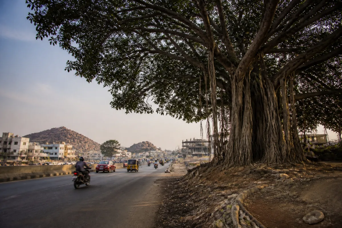
The surviving Hyderabad banyan trees along the Chandrayangutta–Pahadishareef road are more than remnants of an older landscape. They mark the physical transformation of a route that once passed through hillocks, open countryside and a small number of villages but now functions as a busy highway connecting southern and eastern Hyderabad with the Rajiv Gandhi International Airport.
The change has been gradual enough to become part of everyday life, but the remaining trees make the scale of that transformation visible. Road-widening works have removed many of the banyans that once defined the route, while some of those that remain have lost branches. A fully grown banyan near Errakunta still stands as a familiar landmark for residents, even as the highway around it carries more traffic and serves a wider regional network.
The story of this road is therefore not only about nostalgia. It is also about how infrastructure changes the meaning and function of urban space. A route once remembered as a scenic approach to the Dargah of Baba Sharfuddin at Pahadishareef has become part of a much larger movement corridor. It now supports connections to the airport, the Srisailam highway, the emerging Future City, the Amrabad Reserve Forest and the Srisailam temple.
That expansion has brought a different kind of importance to the road. Earlier, its value was tied to landscape, pilgrimage and the experience of travelling through a relatively open countryside. Today, its value is also measured by connectivity. The highway links settlements and destinations across Hyderabad’s southern and eastern edges, placing the route within the city’s outward growth. The banyans that survive along it reveal what has been lost as that growth has accelerated.
For older residents, the landscape is remembered through the experience of travelling rather than through formal maps or planning documents. Shaik Rabbani, a Chandrayangutta resident, recalled a route with only a handful of villages, mainly at Jalpally and Pahadishareef. He described the hillocks, locally called guttalu, and the large banyan trees that made journeys along the road pleasant.
Abdullah Bahamed, a resident of Barkas, similarly remembers the excitement of travelling through the greenery and scenic surroundings as a child. Syed Asif of Aliabad said that the few trees still standing, including those partially chopped during road expansion, bring back memories of how different the road and its surroundings once were.
These accounts provide a ground-level record of urbanisation. They show that the transformation of a road is experienced not only through new carriageways, traffic volumes or destinations reached faster. It is also experienced through the disappearance of landmarks, shade and visual continuity. When a mature tree is removed, the change is permanent, but it is often treated as a small component of a much larger construction project. For residents, however, the tree may have been part of the route’s identity for decades.
The Chandrayangutta–Pahadishareef road illustrates the tension between regional connectivity and local landscape. A road can become more strategically important as a city expands, while becoming less distinctive at street level. The same widening that enables faster movement can also erase the natural features that once made the journey recognisable.
The available account does not establish how many banyan trees stood along the road, how many were removed, or whether a formal tree inventory was prepared before widening. It also does not specify the dates, agencies, project costs or mitigation measures associated with the works. Those gaps matter because they determine whether the loss was recorded, whether alternatives were assessed and whether surviving trees were treated as assets to be protected or as obstacles to construction.
What is clear from the evidence is the sequence of change. The route was once surrounded by hillocks and open countryside. Urbanisation and road widening altered that setting. Traffic increased. The road acquired a broader highway function. Many banyans disappeared, and some survivors were damaged. The physical evidence remains in the form of the trees that still stand, including the large specimen near Errakunta.
This sequence is common to expanding cities, but the local details are important. Hyderabad’s southern and eastern edges are not simply empty spaces waiting for development. They contain pilgrimage routes, village settlements, hillocks, wooded areas and established travel patterns. As transport links improve, these landscapes become more accessible and more exposed to construction pressure. Connectivity can draw new activity to a corridor, but it can also reduce the qualities that made the corridor significant to existing communities.
The road’s connection to the airport further changes its role. A route used by local residents and visitors to Pahadishareef is also part of the movement system serving a major regional gateway. Its connection with the Srisailam highway gives it importance beyond the immediate neighbourhood. References to the Future City, Amrabad Reserve Forest and the Srisailam temple place the corridor within a wider network of urban expansion, regional travel and pilgrimage.
That wider network makes decisions taken along the road more consequential. The removal of one tree may appear local, but the cumulative effect of removing many mature trees changes the character of an entire corridor. The surviving banyans now function as informal markers of the older landscape, allowing residents to compare the present highway with the route they remember.
The institutional question is how such comparisons enter infrastructure planning. Road projects are generally designed around movement, safety, capacity and construction requirements. The source account does not identify the authority responsible for the widening or describe the permissions governing tree removal. It therefore cannot establish whether the surviving banyans were protected through a specific plan or whether their presence is incidental.
That absence of detail is itself significant. Without public information on tree counts, removal permissions, compensatory planting or design alternatives, residents are left to judge change through visible damage and memory. A partially chopped tree communicates the cost of widening more directly than a project document may do. A surviving tree near Errakunta becomes a landmark not because it has been formally designated, but because people continue to recognise it.
The story also shows why environmental questions in cities cannot be separated from transport planning. Mature banyans provide shade and visual relief, but their value in this account is broader. They helped define the identity of the road and made travelling through it a distinct experience. Once the route became a busy highway, that identity was weakened. The road gained capacity and regional significance while losing parts of its older landscape.
There is no evidence in the supplied material to quantify the traffic increase, measure the environmental effects of tree loss or compare the route with other Hyderabad corridors. Nor does the account establish whether replacement trees, if any, have reached comparable maturity. The evidence supports a narrower but important conclusion: infrastructure-led change has altered the road’s physical and cultural character, and the few remaining banyans make that change legible.
For planners and administrators, the corridor raises a practical record-keeping issue. Mature trees along expanding roads should not be treated only as isolated objects within a construction boundary. Their location, size, condition and relationship with settlements can help explain how a road functions for local communities. Such documentation would not eliminate the need for widening, but it would make the trade-offs visible before the landscape is changed.
For residents, the surviving banyans provide continuity in a place where almost everything else has changed. They connect present-day highway travel with an earlier route through villages, hillocks and open land. For the city, they offer a reminder that mobility infrastructure does not merely carry people across a landscape; it also reshapes the landscape being crossed.
The Chandrayangutta–Pahadishareef road’s transformation is therefore both a local memory and an urban planning record. It confirms the pressure placed on older natural landmarks when a route becomes part of a growing metropolitan and regional network. What remains unclear is whether the surviving trees will be protected as the highway continues to expand. For now, they stand as living markers of a countryside that urbanisation has largely replaced.

