


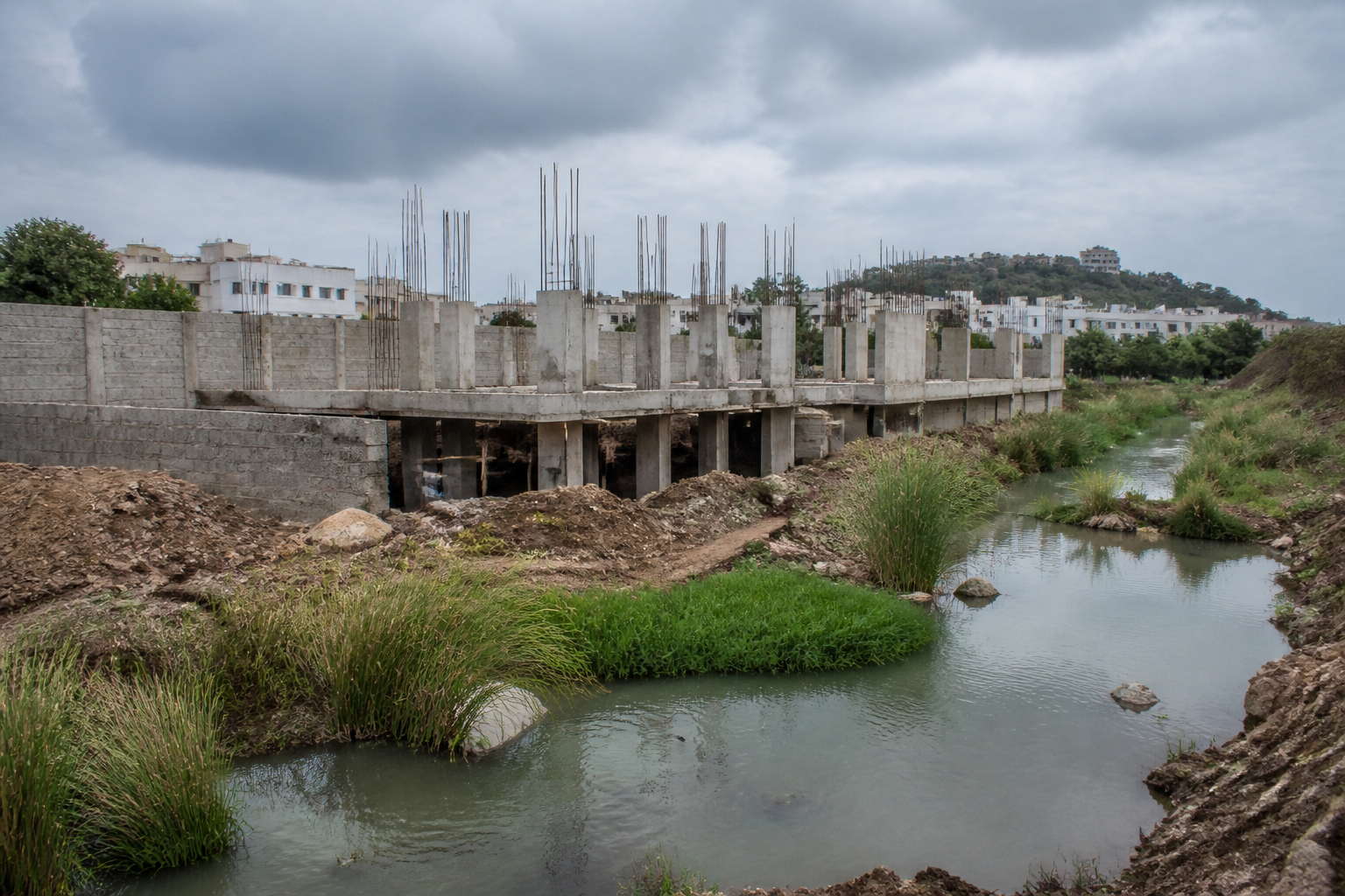
A villa project in Koheda, on Hyderabad’s expanding urban edge, has continued construction despite irrigation and revenue officials identifying alleged encroachments on three feeder channels connected to Chinna Cheruvu. The case is not only about one development: it shows how a water-flow risk can remain unresolved even after inspections, demarcation, written warnings and referrals between government agencies.
The project is located in survey numbers 155, 156, 159, 160, 161, 163, 164 and 167 in Koheda village, Abdullapurmet mandal. According to correspondence and inspection reports accessed by the Times of India, a canal and streams pass through survey number 156 from south to north and function as feeder channels for Chinna Cheruvu near Pedda Amberpet. The water body is identified in the report as HMDA lake ID No. 1962.
The irrigation department’s latest communication, dated October 6, said the developer had not obtained a no-objection certificate or prior permission from the department. N Vijender Reddy, deputy executive engineer of irrigation sub-division-3, Hyderabad, wrote to the Abdullapurmet tahsildar about the alleged encroachment and said he had also written to the tahsildar and municipal authorities in the Adibhatla zone of the Greater Hyderabad Municipal Corporation.
The timeline recorded in the report is significant. Irrigation officials conducted a first inspection on September 15, 2025. They reportedly found that parts of the project had come up within the maximum flood level area and the buffer zone of the Chinna Cheruvu feeder channel. The inspection report warned that construction could obstruct the natural movement of water and create inundation and flooding problems in upstream areas.
A second joint inspection was carried out on September 25, 2025, involving revenue and irrigation officials. The mandal surveyor used toposheets and village maps to demarcate the project boundaries and found that a canal passed through survey number 156. The joint report stated that the developers had not made provisions for the stream areas and that feeder channels had been encroached upon.
The report also recorded the physical structures already present at the site: 11 basements with pillars, seven villas, a compound wall and an office building within the maximum flood level and buffer zone. These details matter because they indicate that the dispute concerns construction already under way, rather than a project still at the proposal stage.
After the inspections, the irrigation department wrote to the Abdullapurmet tahsildar, the Turkayamjal municipal commissioner and Adibhatla municipal authorities on several occasions. The communications, including letters issued in February 2026 and again in October, sought cancellation of the layout and villa project approvals and urged the authorities to take action. Officials told the Times of India that no action had been taken so far and that construction had allegedly continued.
This sequence reveals the administrative problem at the centre of the case. Different agencies appear to hold different parts of the decision-making chain: the irrigation department identifies the water-channel and flood-level concerns; revenue officials help establish boundaries and land records; municipal authorities are involved in local approvals and enforcement; and district-level officials receive complaints and referrals. Yet the presence of multiple agencies has not produced a final intervention at the site.
That gap is important in peri-urban Hyderabad, where development often advances across administrative boundaries. Koheda is in Abdullapurmet mandal, while the correspondence also refers to Turkayamjal and Adibhatla municipal authorities and to the GHMC’s Adibhatla zone. The case therefore involves not just a developer and one local office, but a network of institutions whose jurisdictions overlap around a changing urban edge.
The available documents also show the limits of inspection without enforcement. The first inspection reportedly identified a possible obstruction to water flow. The second inspection added a joint survey, mapped the canal using village records and toposheets, and documented structures at the site. Subsequent letters asked for approvals to be cancelled. However, the reported continuation of construction suggests that recording a violation and stopping development are separate administrative tasks.
The flood-risk concern is similarly specific. Officials did not merely object to the project on general environmental grounds. They identified feeder channels, a maximum flood level area and a buffer zone, and warned that blocking natural drainage could affect upstream areas. In this context, a channel that may appear minor on a development site has a wider function: it carries water towards the lake and forms part of the drainage system during high-flow conditions.
The case also raises a question about how development approvals account for water systems that are not always visible as large, permanent water bodies. A lake can be identified and listed, as Chinna Cheruvu is in the report, while its feeder channels pass through individual survey numbers and developed parcels. If those connecting channels are not preserved in layout decisions and on-site construction, protection of the lake alone may not protect the larger hydrological system described by irrigation officials.
The institutional record supplied in the report does not establish how the project received its approvals, which specific authority granted them or whether any approval was later suspended. It does establish that the irrigation department said no irrigation NOC or prior permission had been obtained, and that it requested cancellation of the layout and villa project approvals. The distinction is important: an alleged lack of one department’s clearance does not, by itself, explain the complete approval process, but it does show that the project’s regulatory status was contested while construction proceeded.
The complaint’s movement through the system adds another layer. Residents of Koheda raised the issue during the chief minister’s Prajavani programme on October 6. Sources cited by the Times of India said the complaint was subsequently forwarded by the state nodal officer to the irrigation department and the Rangareddy district collector. The referral creates a fresh administrative step, but the material supplied does not record a final decision by the collector, the municipal authorities or any other agency.
The result is an unresolved chain: inspection, identification, correspondence, requests for cancellation, a public complaint and another referral. At each stage, the evidence points to official awareness of the alleged encroachment. What remains unclear from the available material is whether construction approvals will be cancelled, whether work will be stopped, whether the disputed structures will be removed, and how the feeder channels will be restored or protected.
For residents, the immediate issue is not only the legality of a villa project. It is whether a drainage route identified by government officials will remain open during periods of heavy water flow. For the administration, the issue is whether documents and inspections can be converted into timely enforcement when a project has already acquired physical form. For the urban region, the case illustrates how development pressure at the edge of the city can turn small gaps between land records, water management and municipal approvals into larger flood-risk questions.
The next developments will depend on the action taken by the irrigation department, the Rangareddy district collector and the relevant municipal and revenue authorities after the October 6 complaint and referral. The supplied report does not record a final enforcement order. Until one is issued, the Koheda project remains a case in which official warnings and alleged continued construction exist side by side.
